Have Questions?
+977 9767224414Unmissable holidays deals - Save up to 20%
Manaslu Circuit Trek
Duration
16 Days
Trip Difficulty
Difficult
Max. Altitude
5,106m
Destination
Nepal
Group Size
2-16 People
Accommodation
Hotel, Teahouse
Transportation
Tourist Bus
Meals
B L D
Explore more facts about the trip
Overview of Manaslu Circuit Trek
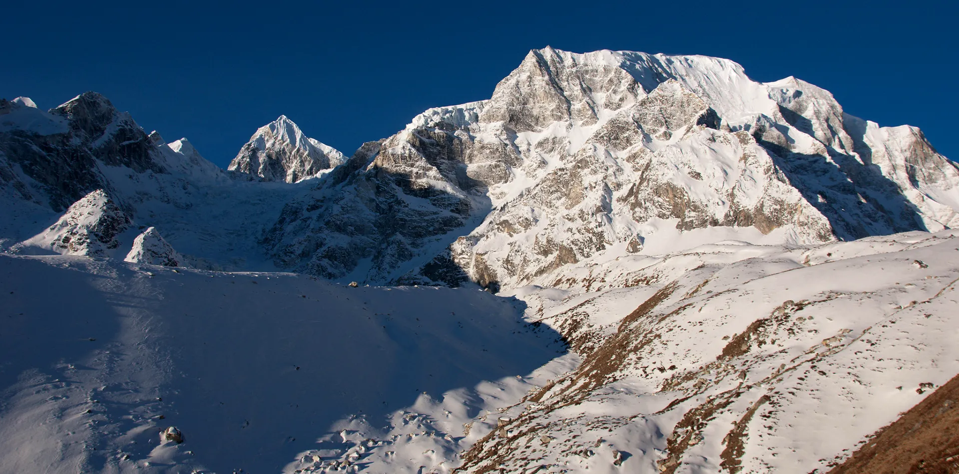
The Manaslu Circuit Trek takes us through Nepal’s hidden Himalayan corridor. We walk 160 kilometers over 14 days. The trail circles Mt. Manaslu, the eighth-highest peak in the world at 8,163 meters. We cross Larkya La Pass at 5,160 meters, which is one of the highest and most challenging high-altitude mountain passes in the country. We start the trek from Soti Khola at 730 meters, and we end the journey in Besisahar after exploring and descending from the high mountains.
On this trek, we have to enter the Manaslu Conservation Area and the Manaslu Restricted Area, which requires two different permits. The Manaslu Restricted Area Permit and the Manaslu Conservation Area Permit. We also need the Annapurna Conservation Area Permit for the Annapurna part of the itinerary. As your trekking partner, Morning Star will arrange all documents and permits on your behalf. However, you must carry passport copies and photos.
We trek through diverse landscapes, starting from the lower section follows the Budhi Gandaki River. We pass subtropical forests with sal and banana trees, where we see monkeys near Machha Khola. The trail then eventually climbs into alpine zones, having us walk past pine and juniper forests. Above 3,500 meters above sea level, vegetation thins and we enter a high arid landscape with icy and snowy grounds.
We pass through the Nubri Valley side trails; these areas are culturally Tibetan. We also get to see gompas in Samdo and Ghap, where monks chant in the morning, and you can even join their morning prayer sessions. Mani walls line the trail, in addition to prayer flags covering the ridges and notable entrance points. We stay in basic teahouses where rooms have wooden beds and shared bathrooms. Most lodges now have solar power, offering an uninterrupted electricity supply during times of power outages..
Water comes from taps or springs, and we always advise treating it with iodine or filters. Meals are very simple throughout the trek; we will eat dal bhat, Tibetan bread, and mostly potato-based dishes. However, a few Western options are also available throughout the trek. Teahouses offer tea, soup, and instant noodles. We avoid raw vegetables as it can upset your stomach, and carrying snacks or energy bars is recommended.
- Safety first, always
- Best prices guaranteed
- Expert travel team
- Easy booking, no extras
- Customize your journey
Based on 10 reviews

Trip Highlights
- Walk a 160-kilometer route around Mt. Manaslu, the eighth-highest mountain in the world at 8,163 meters.
- Cross Larkya La Pass at 5,160 meters, one of Nepal’s highest and most demanding trekking passes.
- Enter the Manaslu Conservation Area, a region closed to tourists until 1991.
- Pass through culturally rich villages like Samdo, Lho, and Ghap, where residents speak Tibetan dialects and follow Vajrayana Buddhism.
- See ancient monasteries in Samdo and Samagaun, including the 400-year-old Pungyen Gompa.
- Walk through the Nubri Valley, where stone houses, yak herds, and mani walls define the landscape.
Photo and Video Gallery


Manaslu Circuit Trek Detail Itinerary
Day 01: Drive from Kathmandu to Soti Khola
We leave Kathmandu at around 6:00 AM, starting the 9-hour road trip, covering 125-140 kilometers in the process. The route follows the Trishuli River, passing through many towns and settlements along the highway. You can see terraced fields and rice paddies, where farmers work with hand tools.
We cross several rivers on metal bridges with high water levels in the morning. We arrive in Soti Khola at around 3:30 PM. The village has a couple of teahouses, and we will choose the one near the river, as much as possible. We eat dal bhat with some sides of veggies and call it a night. You should also prepare for the first trekking day of the Manaslu Circuit Trek. The day ends at around 9:00 PM. The flowing water of the river offers an ambient sleeping sound.
Max. Altitude: 730m/2,395ft. (Soti Khola)
Meal: Breakfast, Lunch & Dinner
Accommodation: Lodge
Day 02: Trek from Soti Khola to Machha Khola
We start the trek after breakfast at 8 in the morning. The trail follows the Budhi Gandaki River, having us walk on dirt and stone paths. Soon enough, the trail passes through a subtropical forest where many sal and banana trees thrive. Monkeys cross this part of the path infrequently. After that, you have to climb over a small ridge at 1,000m. The path can be slippery at times, so we recommend wearing gripped shoes.
Following that, we have to walk through the village of Lapubes, going through a police checkpoint. There, we have to show our permits before continuing any further. We then cross a suspension bridge, it is about 50 meters long. Not long after, we arrive at Machha Khola riverside village, at around 2:00 PM. We stay in a wooden teahouse, have some locally prepared dishes, perhaps some thukpa and dal bhat. It’s important to dry our shoes near the stove before heading to bed.
Max. Altitude: 890m/2,920ft. (Machha Khola)
Meal: Breakfast, Lunch & Dinner
Accommodation: Teahouse
Day 03: Trek from Machha Khola to Doban
Leaving Machha Khola after breakfast, the trail runs along the Budhi Gandaki River. The water is gray because of the heavy concentration of sediments and sand. Soon after, we have to pass through a dense forest where the path is narrow. En route to crossing the forest, we cross three wooden footbridges. Quickly moving through hazard-marked zones, we will pass a landslide-prone area. Signs of the debris show recent rockfall.
After a while on the trail, we pass the village of Shyangbu, featuring a school and a prayer wheel wall. From there, the climb to Doban is gradual. Day 3 of the Manaslu Circuit Trek gains us 180m, covering a total distance of 5.5 kilometers. The village of Doban sits at the confluence of two rivers. After arriving at around 1:30 PM, we will stay in a comparatively new teahouse.
Max. Altitude: 1,070m/3,510ft. (Doban)
Meal: Breakfast, Lunch & Dinner
Accommodation: Teahouse
Day 04: Trek from Doban to Philim
Starting the 4th day of the Manaslu Circuit Trek, the trail climbs steadily as we go over a series of stone steps. We soon pass through pine and oak forests, reaching 1,300m the trees are thinly covering the forests. After some time, open slopes appear on our right, and we cross a suspension bridge. This is the part of the trek where we enter the Nubri Valley. The landscape dramatically changes as we enter the valley. Stone houses replace wooden ones, with a monastery at 1,400m.
Soon after, we will reach our destination of the day, Philim, a large village with around 65 homes. We will stay in a family-run teahouse with rooms that have two beds each and a window facing the valley. Before heading to the tea house, we will have our permits checked at the village checkpoint. Potato stew and local flat bread are the main dishes of the village.
Max. Altitude: 1,570m/5,151ft. (Philim)
Meal: Breakfast, Lunch & Dinner
Accommodation: Teahouse
Day 05: Trek from Philim to Deng
Day 5 of the Manaslu Circuit Trek follows the Budhi Gandaki River upstream. The valley narrows as we gain more elevation, featuring rock walls that rise sharply on the left. We walk on a trail carved into the cliffside with some sections that are slippery after overnight moisture. We recommend using trekking poles for balance. Then, we pass through the village of Namrung, featuring a health post and some small shops.
In total, today’s trail climbs 290m over 6 kilometers of trekking distance, with an overall steady gradient. We will take breaks every 45 minutes or an hour to keep ourselves from being completely exhausted. You can see prayer walls with carved mani stones en route. The village of Deng sits in a wide part of the valley, featuring wooden houses with slate roofs. Most of the owners keep yaks and grow buckwheat.
Max. Altitude: 1,860m/6,102ft. (Deng)
Meal: Breakfast, Lunch & Dinner
Accommodation: Teahouse
Day 06: Trek from Deng to Ghap
The following day of the Manaslu Circuit Trek itinerary starts with a trail that moves through a pine forest. Needle-shaped leaves cover the ground. After a short while, we have to cross a wooden bridge at 1,900m with a fast-flowing river below. The path climbs through open meadows and passes herders’ stops with flocks of cattle. We then enter a region with fewer trees and plants; shrubs and grass dominate the landscape.
We then walk past the village of Chhokate, featuring about ten homes and a Buddhist prayer flag pole. There are no teahouses in the village. Leaving Chhokate, the village of Ghap appears ahead. The teahouses in Ghap have solar power since hydroelectricity is very unreliable. You can charge your devices at the common table at a price. Our dinner will likely be vegetable curry, flat bread, and boiled potatoes.
Max. Altitude: 2,250m/7,382ft. (Ghap)
Meal: Breakfast, Lunch & Dinner
Accommodation: Teahouse
Day 07: Trek from Ghap to Namrung
Day 7 of the Manaslu Circuit Trek starts at Ghap. The trail climbs steadily through a dry, rocky valley, passing through pine and juniper forests. The wind can be strong in open sections. After some time, we have to cross several small streams over stone bridges, leading us to the village of Sho. It has stone houses and prayer wheels, offering a charming scene. We see mani walls along the trail as the path rises on a series of switchbacks.
We reach Namrung by mid-afternoon, sitting on a ridge, with views of Simnang Himal and Punggen Peak. We stay in a teahouse with solar-heated rooms for the night. The dinner for the night is likely going to be dal bhat with pickled or cooked vegetables.
Max. Altitude: 2,660m/8,727ft. (Namrung)
Meal: Breakfast, Lunch & Dinner
Accommodation: Teahouse
Day 08: Trek from Namrung to Lho
We leave Namrung after breakfast, and the trail climbs through a high meadow. You might see ibex tracks near the ridge as the path follows the edge of a glacial moraine. We pass through the village of Lihi. It is one of the highest farming villages in Nepal. The locals of the village grow barley and rear yaks and other Himalayan cattle.
We continue the trek along a wide valley, heading west. The peaks of Manaslu and Ngadi Chuli dominate the skyline as we cross a stream at 3,000m. The trail ascends steadily as
Lho appears ahead, surrounded by boulders and prayer flags. The village has a small monastery, which we will visit briefly. You can eat noodle soup and drink ginger tea at the accommodation for the night. Oxygen levels are 70% of sea level, so we have to be careful about altitude sickness.
Max. Altitude: 3,180m/10,433ft. (Lho)
Meal: Breakfast, Lunch & Dinner
Accommodation: Teahouse
Day 09: Trek from Lho to Samagaun
Today, we leave the village of Lho and climb through a boulder field. We follow a single file path along the lateral moraine. Manaslu’s north face rises directly ahead as the glacier looms at 7,000m. We pass through Shyala, featuring one teahouse and a stone shelter. Wind gusts reach 40 km/h on exposed sections, so windproof layers are recommended.
The trail descends slightly before the final climb to Samagaun. We cross a wooden bridge over a glacial stream where water flows year-round from the Milam Glacier. We arrive in Samagaun by 2 PM, where houses have slate roofs and prayer flags on rooftops. We stay at a teahouse with running water and hot showers available. We eat dal bhat, boiled eggs, and some sides of veggies.
Max. Altitude: 3,530m/11,581ft. (Samagaun)
Meal: Breakfast, Lunch & Dinner
Accommodation: Teahouse
Day 10: Rest Day in Samagaun
After a filling breakfast at 8, we pack light for the one and only acclimatization hike on the Manaslu Circuit Trek itinerary. We hike to near the glacier viewpoint at 4,000m, which takes 2 hours round-trip. We will move slowly, stopping every 20 minutes or so to breathe and rest. You can see crevasses and ice seracs on the glacier. The terminal moraine is 500m wide.
Back in Samagaun, we will have a relaxing lunch and rest for the time being. You can drink lemon tea with honey, have some local dishes, and just make the most of your time in the mountains. Unlike the previous days, wind speeds are low there and will remain the same for the next two days. You might have to use sleeping bags rated to -10°C, as the blankets might not be enough.
Meal: Breakfast, Lunch & Dinner
Accommodation: Teahouse
Day 11: Trek from Samagaun to Samdo
Day 11 of the Manaslu Circuit Trek starts with a trail that climbs through a glacial valley. We walk on compacted dirt and rock, over a path that follows the right side of the Buhi Gandaki River. Soon enough, we will pass chortens with faded mani stones, where prayer flags line the ridge above. You will get to see Manaslu’s west face throughout the hike today and also cross a high ridge at 3,700m. To avoid being extremely spent, we will take short breaks every 30 minutes.
We descend slightly to the village of Chhoku. It has two teahouses and a small shrine; you can refill your water bottles at the village. Continuing the trek, we will get to the village of Samdo after about 45 minutes. This village sits below a steep cliff and has many stone houses and yak pens. We stay in a teahouse with a tin roof, where we will be served vegetable thukpa and dal bhat.
Max. Altitude: 3,875m/12,713ft. (Samdo)
Meal: Breakfast, Lunch & Dinner
Accommodation: Teahouse
Day 12: Trek from Samdo to Dharamsala
We start the day 12 of the Manaslu Circuit Trek at around 7:30 AM. The trail ascends a wide valley as we walk on moraine debris and gravel. The air thins quickly, and we take a break every now and then to keep the ascending pace safe. We pass the last tree line at 4,000m, after which no vegetation grows. Crossing three small streams, the trail continues ascending.
After a while, we reach the final climb of the day. This part of the trek is very steep, gaining us 400m of elevation in just 2.5 hours. We have to climb up slowly and maintain a steady rhythm. Dharamsala is a seasonal settlement where a couple of teahouse operates during trekking season.
Max. Altitude: 4,480m/14,698ft. (Dharamsala)
Meal: Breakfast, Lunch & Dinner
Accommodation: Teahouse
Day 13: Trek from Dharamsala to Bhimtang via Larkya La Pass
Today, we need to cross the Larkya La Pass before the afternoon winds. Day 13 of the Manaslu Circuit Trek climbs for a total of 5 hours. By the time we reach the top, we gain 680m in elevation. The path is steep and icy in sections. We might have to use crampons and trekking poles to reach Larkya La Pass at around 11:00 AM. The summit has prayer flags and a stone cairn.
You can see Himlung Himal, Cheo Himal, and Annapurna II from the top. The visibility is about 10 km during the trekking season. Clouds begin forming to the east as soon as the afternoon winds come in, so we descend 1,440m to Bhimtang shortly after reaching the top. The first 2 hours are on glacial moraine, featuring loose and slippery trails. Eventually, we will reach Bhimtang, a grassy meadow with a couple of teahouses.
Max. Altitude: 5,160m/16,929ft. (Larkya La Pass)
Meal: Breakfast, Lunch & Dinner
Accommodation: Teahouse
Day 14: Trek from Bhimtang to Gho
The next day on the Manaslu Circuit Trek itinerary, we have to leave Bhimtang and descend through a pine forest. This part of the trail requires us to walk on packed dirt and stone steps. We cross the Bhimtang Khola on a metal footbridge while water flows fast from snowmelt. Not long after, we will pass through Tilje at 3,000m, where a health post and a school can be seen. You can refill water bottles at a tap stand.
Leaving the village of Tilje, the trail drops steeply through rhododendron and oak trees. We recommend using trekking poles to reduce knee strain. Soon after, we reach Gho at around 2:00 PM. This village has about 30 homes and a monastery.
Max. Altitude: 3,720m/12,205ft. (Bhimtang)
Meal: Breakfast, Lunch & Dinner
Accommodation: Teahouse
Day 15: Trek from Gho to Dharapani
The next day on the Manaslu Circuit Trek, the trail descends along the Marshyangdi River. We follow a well-marked stone path and pass through pine and rhododendron forests. The density of the tree increases as we drop in elevation, crossing several suspension bridges. The longest one en route is just 60 meters. Then, we walk through the villages of Karte and Chamek. Each of the villages has some small shops and water taps.
We see a health post in Karte, which serves three surrounding villages. Leaving Karte, the trail is steep in some sections, requiring us to use trekking poles to reduce strain on our knees. We will arrive in Dharapani at around 2:30 PM. The village has about 50 households, and we will stay in a concrete teahouse after many days of wooden floors and walls.
Max. Altitude: 2,550m/8,366ft. (Gho)
Meal: Breakfast, Lunch & Dinner
Accommodation: Teahouse
Day 16: From Dharapani to Besisahar, then drive to Kathmandu
Today is the last day on the Manaslu Circuit Trek itinerary. We will leave Dharapani at 9:00 AM by jeep. The road is gravel and narrow, keeping us on the tracks for about 2 hours. On the way down, we will pass through Jagat and Tal. These villages have stone houses, health posts, and small schools. You can see the Marshyangdi River widen as we get closer to Besisahar.
From there, we board a private vehicle at around 1:00 PM and drive 8 hours to Kathmandu. The route follows the Prithvi Highway, and we will stop twice for fuel and food. We arrive in Kathmandu at 9:00 PM, check into a hotel, take hot showers, and call it a night after dinner.
Activity: 2 hrs drive
Max. Altitude: 1,910m/6,266ft. (Dharapani)
Meal: Dinner
Accommodation: Hotel
If our standard itinerary doesn't fully meet your needs, we are happy to tailor it to your specific preferences and requirements.
Includes and Excludes
What’s Included?
- Private vehicle transportation from Kathmandu to Soti Khola and Besisahar to Kathmandu
- Hotel accommodation in Kathmandu before and after the trek
- Comfortable teahouse or lodge accommodation during the trek (twin-sharing)
- Breakfast in Kathmandu hotel, and three meals (breakfast, lunch, dinner) each day during the trek
- Professional, English-speaking trekking guide and required porters
- Trekking guide salary, insurance, meals, accommodation, equipment, transportation, etc.
- Seasonal fresh fruit during the trek
- All necessary trekking permits and national park entry fees
- Basic medical kit and safety equipment during the trek
- Sleeping bag, down Jacket, walking poles, duffel bags (you have to return after the trek)
- Certificate of achievement at the end of the journey
- Government taxes and agency service charges
What is not Included?
- International flights to and from Nepal
- Nepal entry visa fees upon arrival
- Lunch and dinner in Kathmandu
- Personal expenses such as drinks, snacks, hot showers, Wi-Fi, and device charging
- Travel insurance that covers medical emergencies and helicopter evacuation
- Tips for guides, porters, and drivers
- Extra hotel nights caused by flight delays, early arrival, or late departure
- Personal Travel insurance and emergency rescue evacuation
- Extra cost caused by natural or political disturbances beyond our control
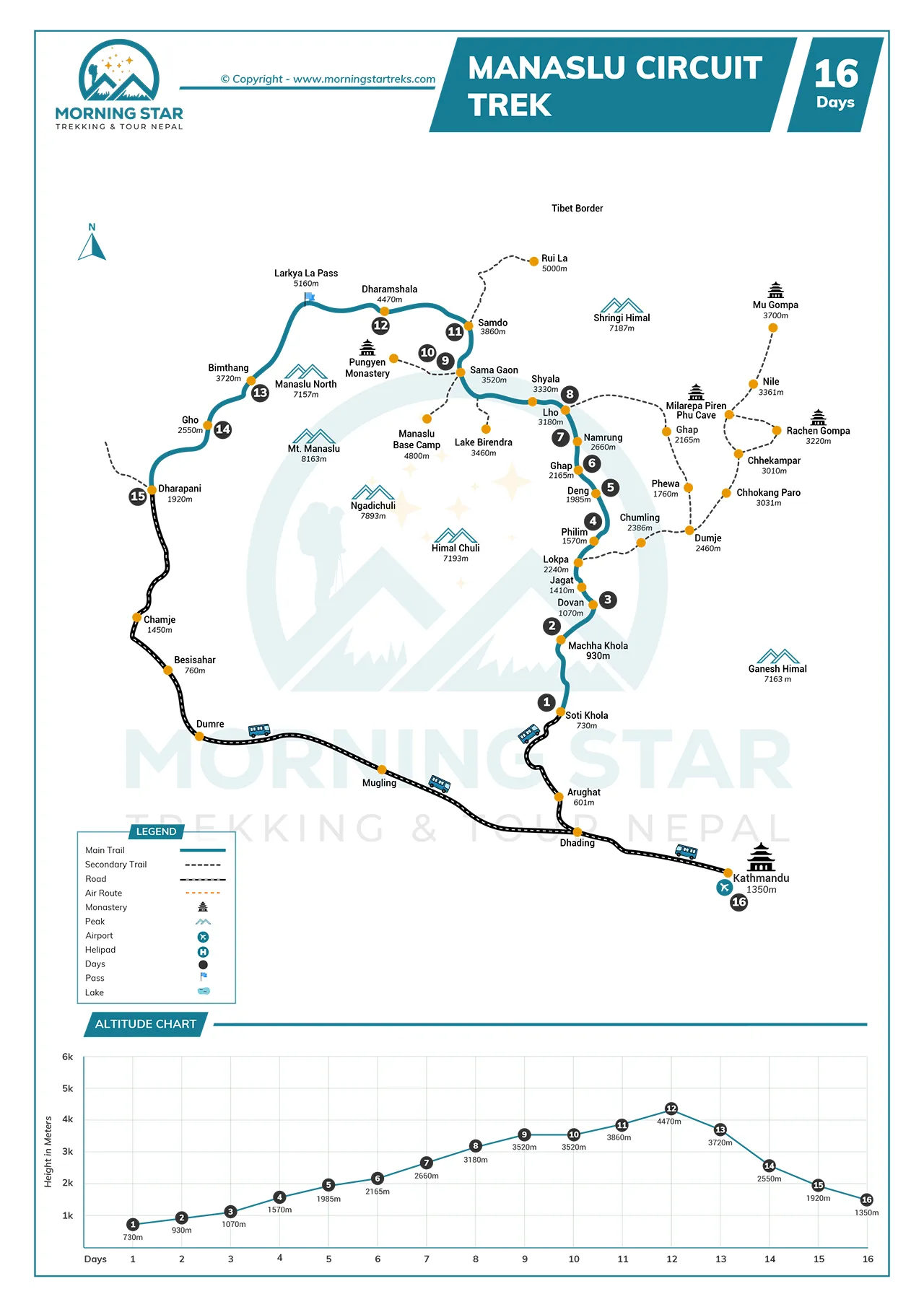
Route Map & Altitude Chart
Trip Information of Manaslu Circuit Trek
Best Season and Weather
We recommend doing the Manaslu Circuit Trek during spring and autumn. March to May is the spring season, and September to November is autumn. These months offer stable weather. We recommend trekkers avoid the monsoon season from June to August as the rain makes trails slippery. Landslides might block paths between Soti Khola and Jagat. Winter trekking is possible, but harsh as the temperatures drop below -15°C at night, above 4,000 meters.
Difficulty
The Manaslu Circuit Trek requires trekkers to walk for 14 days with daily hikes of 5 to 8 hours. The trail has steep climbs and descents, notably the gain of 680 meters from Samdo to Larkya La Pass in 5 hours. Most of the steep ascent paths are rocky and exposed. We use trekking poles on loose scree, like the descent to Bhimtang, which is 1,440 meters over 4 hours.
Altitude Sickness
This Manaslu Circuit Trek requires us to climb above 5,000 meters. Altitude sickness can affect unprepared trekkers with symptoms including headache, nausea, dizziness, and fatigue. The trek guide will monitor oxygen saturation with pulse oximeters. We hike high and sleep low and maintain a slow ascending rate to avoid altitude sickness.
Larkya La is high risk. We cross it after acclimatizing in Samagaun. However, if symptoms appear, we have to stop and descend if the case is severe. Guides carry emergency oxygen for times like these.
Preparation and Fitness
We need strong leg muscles and cardiovascular endurance for the Manaslu Circuit Trek. You have to walk 5 to 8 hours daily over 14 days, reaching the highest point of Larkya La Pass at 5,160 meters. You can gain up to 700 meters in a single climb; this requires training for at least 14 weeks before departure. You have to carry 5 to 7 kilograms during training and walk on stairs, trails, and uneven ground.
Food and Accommodation
All along the Manaslu Circuit Trek, we have to eat in teahouses. Meals include dal bhat, thukpa, noodles, and potatoes. Most lodges do not serve meat above 3,500 meters, and we drink boiled water or use purification tablets. You have to pay extra for hot showers and charging devices, while the rooms have wooden beds and shared toilets. Solar panels power lights in common areas.
We recommend bringing a sleeping bag for warmth as the temperatures drop below freezing at night in Samagaun and Dharamsala. You should avoid raw vegetables to reduce infection risk. Carrying snacks like energy bars and nuts is recommended for quick eats during the trekking days. Most of the teahouses use kerosene stoves for cooking, while some use firewood. We recommend eating early to secure hot food and reusing water bottles to reduce waste.
Transportation
We drive from Kathmandu to Soti Khola in a private jeep. The trip takes 8-10 hours over 175 kilometers. We travel on the same route from Dharapani back to Kathmandu at the end of the trek. The return drive lasts 10 hours. You have to keep passports and permits accessible for police checks on the road. Our backpacks will be tied on the roof or put in the trunk.
Communication
We have a limited phone network on the Manaslu Circuit Trek itinerary. NTC (Nepal Telecom) works in lower villages like Soti Khola, Machha Khola, and Philim. We lose signal above 3,000 meters. We regain partial coverage in Samagaun and Samdo, but some teahouses offer Wi-Fi, which costs $2 to $5 per day. However, the speed can be slow. Our trek guides carry satellite phones to contact emergency services.
Permit
We need three permits for the Manaslu Circuit Trek. The Manaslu Restricted Area Permit costs $100 in autumn and $75 in spring, for the first seven days; each extra day costs $15, while the Manaslu Conservation Area Permit costs $30. We also need the Annapurna Conservation Area Permit, which costs $30. International visitors are required to trek with a licensed guide. Morning Star applies for permits in Kathmandu, while you have to provide two passport photos and a copy of your passport.
We have to carry originals throughout the trek and show them at checkpoints in Jagat, Deng, and Samdo. Make sure to keep them dry and secure, or you can just laminate them before leaving for the trek.
Visa
You will get a Nepali tourist visa on arrival at Tribhuvan International Airport. To get the visa, you have to fill out an online form before arrival or a physical one at the airport. You can choose 15, 30, or 90-day options. You have to pay your visa fees in cash or by a card. We will provide you with a printed itinerary and hotel address as proof of accommodation. Your entire visa processing takes about 60 minutes, while you do not need a visa for children under 10. You can easily extend your visa in Kathmandu or en route if needed.
Travel Insurance
We must have travel insurance before starting the Manaslu Circuit Trek. Your insurance policy must cover high-altitude trekking up to 6,000 meters. Many standard plans exclude climbs above 4,000 meters, so please verify this before departure. Emergency rescue is critical in severe cases of altitude sickness, which the travel insurance must cover. Helicopter evacuations occur from Larkya La or Samagaun if needed. The costs range from $3,000 to $5,000, which the trek package does not cover; your insurance does.
You need to carry a printed copy of the insurance policy and give one to the trekking agency as well. The trek guides need proof during emergencies. Medical coverage must include hospitalization and treatment for altitude sickness at any point during the trek. Some policies deny claims if you ignore the guide instructions. Trip cancellation coverage helps if you cannot start due to injury or personal emergencies
Extra Expenses
You can budget $25 to $35 per day for extras on the Manaslu Circuit Trek. This covers bottled water, snacks, charging devices, and hot beverages. Teahouses charge $1 to $2 to charge phones or cameras, while hot showers cost $3 to $5 at lower elevations. Hot showers are not available after we reach 3,800 meters above sea level. Toilet paper and towel use may add $1 per visit. You have to pay $1 to $2 for boiled water refills, while mineral water costs $2 per liter in Samdo. It rises to $3 in Dharamsala.
Snacks like chocolate, biscuits, and instant noodles cost 2 to 3 times Kathmandu prices. A Mars bar is $2.50 in Samagaun. You are encouraged to tip our guides and porters at the end, unless you are dissatisfied with their performance. Moreover, beverages like tea, coffee, and soft drinks add up. A cup of tea costs $1.50. Beer is $4 in the lower villages, which is not served above 3,500 meters.
Private vs. Group Trek
Most trekkers choose a private trek for flexibility. You can set the start date, control the pace, rest longer in villages, and adjust the itinerary if the weather changes. Group treks, on the other hand, run on fixed dates as you have to join other travelers. Most groups have 2 to 6 people. You can save some money compared to private trips.
Private treks cost more but suit families or friends. Group options work for solo travelers on a budget. Both options follow the same route and permit. Safety standards are equal, and we provide the same guides for both types.
Most Asked Questions
![]() General
General
How many hours do we walk each day on average?
The trek 5 to 7 hours each day. Daily distance ranges from 12 to 16 kilometers.
Are there mobile network signals along the trail?
We have an NTC signal in most villages. Coverage works up to Samdo.
Do we cross any high passes above 5,000m?
We cross Larkya La Pass at 5,160m. It is the highest point on the trek.
Is the trail well-marked between villages?
The trek follows stone cairns and prayer flags. Signs appear at junctions.
What time do we start walking each morning?
The trek starts at 7:30 AM on average. An early start helps us reach before the afternoon weather changes.
![]() Preparation & Fitness
Preparation & Fitness
What level of fitness do we need for this trek?
You need strong endurance. You have to walk 5 to 8 hours daily on steep trails.
Do we need prior high-altitude experience before attempting Larkya La?
Yes. You should have trekked above 4,000 meters before attempting the pass.
How many training hikes should we complete before departure?
You have to do 6 to 8 weekend hikes. Each hike lasts 5 hours or more.
Should we practice with a loaded backpack before the trek?
Yes. We recommend trekkers train with a 10 to 12 kg pack for at least 4 hikes.
Do we walk on uneven terrain during training?
You should walk on rocky trails during the training. We recommend trekkers train 4 to 5 hours per session, twice a week.
![]() Insurance and Visa
Insurance and Visa
How long does it take to get the Restricted Area Permit?
You can get the permit in one day. We apply in Kathmandu with the help of a guide.
Can we extend our trek if we face weather delays?
Yes, we can extend the trek in such cases. Our permit allows up to 14 days in the zone.
Does our insurance need to cover a helicopter evacuation?
Your insurance must cover rescue up to 6,000m. Evacuation from Larkya La is common.
Are rescue services available from Larkya La Pass?
Rescue helicopters operate from Dharamsala, Samdo, Bhimtang, and Samagaun. Weather determines flight feasibility.
Do we need to carry physical copies of our visas and permits?
We carry original permits and visas. Checkpoints require them for verification.
![]() Accommodation and Facilities
Accommodation and Facilities
Are vegetarian options available at every teahouse?
Yes. Every teahouse offers dal bhat, noodles, and vegetable dishes. We eat vegetarian food daily.
Do teahouses have charging points for devices?
Most teahouses have power outlets. We charge phones and cameras for a small fee.
Are sleeping bags provided, or should we bring our own?
Sleeping bags are not provided. We bring our own rated for -10°C or lower.
![]() Food and Drinks
Food and Drinks
What meals are included during the trek?
You get breakfast, lunch, and dinner at each teahouse. Meals are part of the trek package.
Is hot water available for washing every day?
Hot water is available for a fee. We use it for face and hand washing each evening.
![]() Weather & Seasons
Weather & Seasons
What is the best month to do the Manaslu Circuit Trek?
The best month is October. September and November are good alternatives.
What is the average temperature at Larkya La Pass during trekking season?
Larkya La averages -10°C in the morning. Afternoon highs reach -4°C.
Do afternoon storms occur in the Manaslu region? How often?
Afternoon storms occur 2 to 3 times per week during the monsoon season.
Is the trail snow-covered before May or after October?
Yes. Snow frequently falls in said time of the year, which might block the pass at times, if the conditions are heavy.
Does rainfall affect the lower sections between Soti Khola and Philim?
Rain affects trails from July to August. Muddy paths slow progress between Soti Khola and Philim.
![]() Health & Safety
Health & Safety
Are teahouses required to have basic medical supplies?
No. Teahouses are not required to have medical supplies. We rely on our guide’s first aid kit.
Does our guide carry a pulse oximeter and emergency oxygen?
Yes. Our guide carries a pulse oximeter. Some carry emergency oxygen for severe cases.
Where are the nearest health posts on the route?
Health posts are in Jagat, Philim, and Samagaun. They offer basic altitude and injury care.
Do we report headaches or nausea immediately to the guide?
Yes. We report headaches or nausea at once. Early signs can mean altitude sickness.
Is altitude sickness common above 4,000m? What are the first signs?
Yes. Altitude sickness occurs above 4,000m. First signs are headache, nausea, and fatigue.
![]() Booking & Payment
Booking & Payment
What is the deposit amount to confirm our booking?
You have to pay at least a 50% deposit to confirm your booking.
When is the full payment due before departure?
You have to pay the full amount 15 days before the trek starts.
Do we get a refund if we cancel 30 days before the trek?
Yes, you will be partially refunded if you cancel 30 days before departure.
Are trek extensions possible after reaching Samagaun?
We can extend to the Tsum Valley or explore the Nubri Valley more with prior arrangement.
Can we transfer our booking to another person?
Yes, you can transfer your booking to another person with no fee.
![]() Transportation & Flight
Transportation & Flight
Is the Kathmandu to Soti Khola drive on paved or unpaved roads?
The road is paved for the most part. The last 18km to Soti Khola is unpaved.
How many people travel per vehicle during the transfer?
We travel 6 to 7 per jeep. Each person gets a seat with a seatbelt.
Do we use the same vehicle for the return from Besisahar?
Yes. It is the same kind of vehicle, but not exactly the same.
How long is the drive from Dharapani to Kathmandu?
The drive takes 9 to 10 hours. It covers 120km on mixed road conditions.
Do we stop at roadside restaurants for meals during the drive?
Yes. We stop at two roadside restaurants.
- Safety first, always
- Best prices guaranteed
- Expert travel team
- Easy booking, no extras
- Customize your journey
Based on 10 reviews
Have Questions?
+977 9767224414