Have Questions?
+977 9767224414Unmissable holidays deals - Save up to 20%
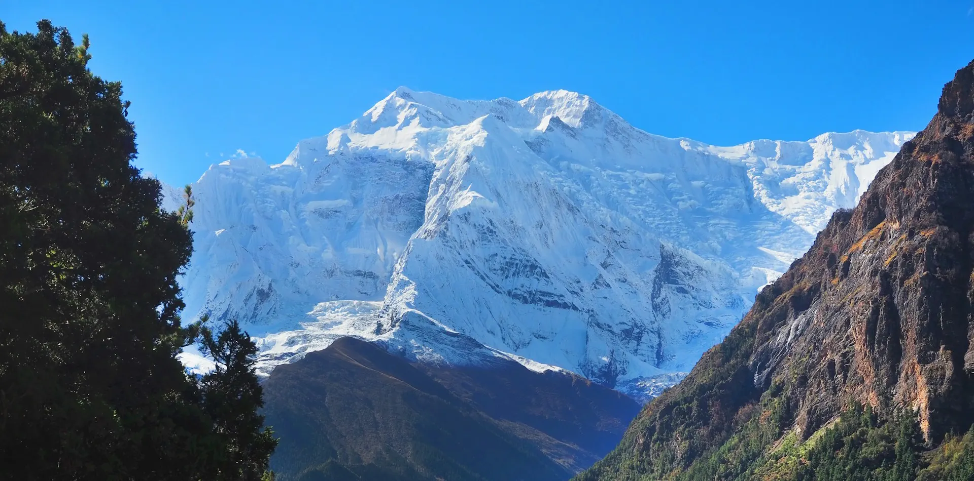
Annapurna Circuit Trek
Duration
18 Days
Trip Difficulty
Challenging
Max. Altitude
5,416m
Destination
Nepal
Group Size
2-16 People
Accommodation
Hotel, Lodge
Transportation
Tourist Bus
Meals
Breakfast, Lunch & Dinner
Explore more facts about the trip
Overview of Annapurna Circuit Trek
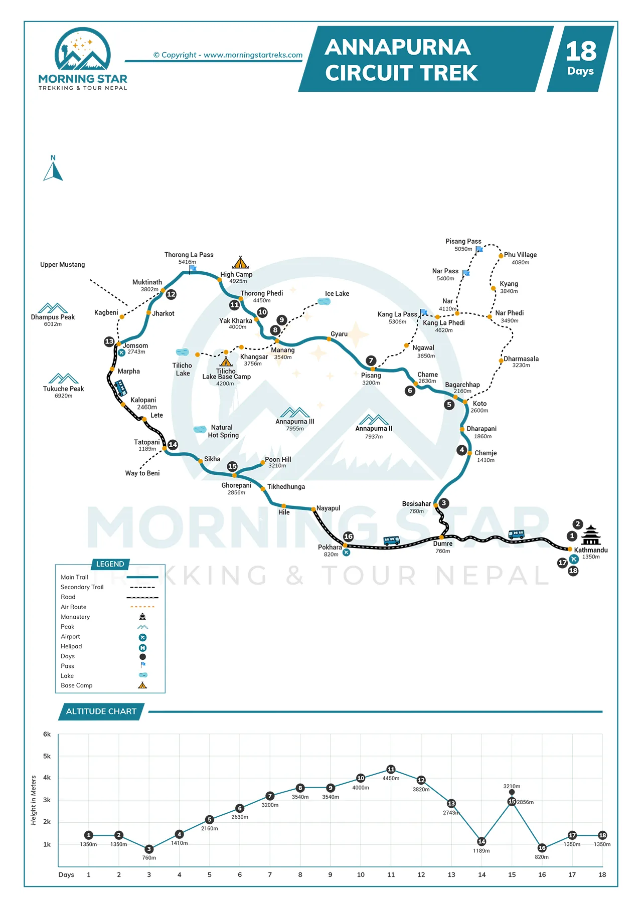
Trekking the Annapurna Circuit Trek in Nepal covers 160 to 230 kilometers. Based on the starting and ending points of the particular itinerary, this trek can be over or under 200 km long. The itinerary that we have selected starts from Besisahar at 760 meters. We end in Jomsom at 2,720 meters. The highest point en route is Thorong La Pass at 5,416 meters, offering the best panoramic view of the mountains. Every single day on the highlands, we have to trek 6 to 8 hours with an average elevation gain of 300 to 500 meters.
We sleep in teahouses, which are the standard accommodation establishments in the mountains. They are very basic, but an inseparable part of the journey. They have shared rooms and squat toilets with a communal dining hall. Hot water costs extra, and so does device charging and WiFi connectivity. We need to carry water purification tablets as untreated water risks different types of illness that can be very inconvenient while trekking..
We need two permits in order to legally do the Annapurna Circuit Trek. We can get the TIMS card and Annapurna Conservation Area Permit in Kathmandu or Pokhara at the Tourism Board Office. The cost is 3,000 NPR for foreign trekkers, which will be covered by the trek package. Many people prefer the autumn season, lasting from September to November, to visit the highlands of Nepal. Spring is also one of the best times to do this trek, lasting from March to May. Over 50,000 people complete this trek each year, with a high success rate.
Roads now reach Chame and Manang, considerably higher than our starting point, but we will avoid the jeep trails and go over the remote trekking trails. If you prefer, we can arrange an itinerary where you can skip the lower section. We see Annapurna II, III, IV, Gangapurna, and Dhaulagiri from most of the viewpoints along the way. Manaslu is visible on clear days as well; however, the weather conditions can change fast in the unpredictable mountains.
This trek is physically demanding, requiring us to train before departure. Cardio and leg strength reduce injury risk and also prepare us for the long walks over rugged trails. We also have to prepare for cold, wind, and long acclimatization days. We follow the trail markers and keep a close eye on our physical well-being. We stay hydrated and eat regular meals, and keep our pace steady to avoid any altitude-related sickness.
- Safety first, always
- Best prices guaranteed
- Expert travel team
- Easy booking, no extras
- Customize your journey
Based on 10 reviews

Trip Highlights
- Cross Thorong La Pass at 5,416 meters, one of the highest trekking passes in the world.
- Walk through five climate zones, starting in subtropical lowlands, and ending in arid highlands near Muktinath.
- Witness grand scenes of Annapurna II, III, IV, Manaslu, Dhaulagiri, and Gangapurna.
- Pass through many traditional villages, including Pisang, Dharapani, Jagat, and more.
- Visit the highly revered temple of Muktinath.
- Explore the preserved nature of the Annapurna Conservation Area.
Photo and Video Gallery


Annapurna Circuit Trek Detail Itinerary
Day 01: Arrival at Kathmandu
On the first day of the Annapurna Circuit Trek, you land at Tribhuvan International Airport in Kathmandu. There, you will meet our representative right at the exit. Then, we travel to our hotel in a private vehicle, with a stop to exchange money if we need Nepalese rupees. For the time being, you can rest or start light exploration. At our office, you will get the first briefing about the trek. This will also be a welcome meeting, where you will be introduced to the crew members and other trekkers in the group.
Activity: 30 mins drive
Max. Altitude: 1,400m/4,593ft. (Kathmandu)
Meal: Breakfast
Accommodation: Hotel
Day 02: Kathmandu sightseeing tour
Day 2 of our trek begins with a full-day sightseeing tour in Kathmandu. We start at the Kathmandu Durbar Square in the heart of the city, exploring historic palaces, temples, and courtyards. We will observe local artisans at work and the daily life of the locals. We will then move towards Swayambhunath Stupa, also known as the Monkey Temple, where we walk around the stupa and spin prayer wheels. The next stop is Boudhanath Stupa, one of the largest Buddhist stupas in the world, and observe monks performing rituals.
Following that, we will visit Pashupatinath Temple, a major Hindu temple on the Bagmati River, witnessing ceremonies and cremation rituals at the riverbanks. At around 1 PM, we will stop for lunch at a local restaurant offering Nepali cuisine. As you visit different sites, the guide explains the cultural and historical significance of each site. In the evening, we return to our hotel. Then, we will review trekking gear, prepare permits, and rest or explore nearby markets.
Max. Altitude: 1,400m/4,593ft. (Kathmandu)
Meal: Breakfast
Accommodation: Hotel
Day 03: Drive to Besisahar and continue to Nagdi by local bus
Starting the 3rd day of the Annapurna Circuit Trek, we walk onto our vehicle for the drive to Besisahar. We will travel 190–200 km on asphalt roads and pass through Mugling, Dumre, and Besisahar. The road goes past terraced farms, rivers, and small villages, with plenty of chances to observe locals farming and markets. Soon after, we will leave the highway and ride onward into the hills.
Departing from the Prithvi Highway, have to drive through rocky, subpar roads. We stop for lunch at a roadside eatery and settle into our room after eventually reaching Besisahar.
Meal: Breakfast, Lunch & Dinner
Accommodation: Lodge
Day 04: Trek to Chamje
Day 4 of our Annapurna Circuit Trek takes us from Nagdi to Chamje. We have to start early after breakfast and follow a well-marked trail along the Marsyangdi River. We will pass small villages, suspension bridges, and terraced fields, and walk through forested paths with occasional river views. You can see local farmers working in the fields and interact with villagers at times. The section of the trail involves gradual ascents with short downhill sections
We have to maintain a steady pace to conserve energy and adjust to the altitude. We will soon reach Chamje, probably in the afternoon, and settle into a lodge, check our gear, and hydrate. We will have a simple Nepali meal for dinner. Before heading to bed, a review of the next day’s route is necessary. This day covers approximately 13 to 15 km and takes around 5 to 6 hours of walking, providing a smooth introduction to trekking while showing Himalayan scenery and local village life.
Activity: 5-6 hrs trek
Max. Altitude: 1,430m/4,692ft. (Chamje)
Meal: Breakfast, Lunch & Dinner
Accommodation: Lodge
Day 05: Trek from Chamje to Bagarchhap
On Day 5 of our Annapurna Circuit trek, we will trek from Chamje (1410 m) to Bagarchhap (2160 m). This day involves a 4-6 hour hike covering about 15 km, with an elevation gain of 750 meters. We will follow the Marsyangdi River through diverse landscapes and cultural sites. We have to leave our teahouse after breakfast, typically around 7-8 AM, to maximize daylight and avoid afternoon heat. Chamje, a small village, is the destination of the day.
The trek begins with an uphill climb through narrow valleys, leading us to cross the Marsyangdi River via a suspension bridge near Tal village, about 1-2 hours from Chamje. Tal, at 1,700m, marks our entry into the Manang district. After that, we walk through rhododendron, pine, and bamboo forests, and as we approach Dharapani (1,860m), we see ancient chortens and mani walls, reflecting Tibetan Buddhist influence. We will reach Bagarchhap by late afternoon.
Activity: 4-6 hrs trek
Max. Altitude: 2,160m/7,087ft. (Bagarchhap)
Meal: Breakfast, Lunch & Dinner
Accommodation: Lodge
Day 06: Trek from Bagarchhap to Chame
On Day 6 of our Annapurna Circuit trek, we have a 5-6 hour trek that covers about 16 km with a 490 m elevation gain. The village’s stone houses and Buddhist monastery provide a scenic backdrop as we set out in the morning. We have to follow a trail along the Marsyangdi River, entering dense pine and fir forests. The path is mostly flat initially, offering a gentle start with sounds of the river’s flow and small waterfalls.
We then cross a suspension bridge over the Marsyangdi River near Koto, about 2-3 hours into the trek. This path goes through small settlements like Timang and Dhikur Pokhari. Timang, at 2,500m, offers stunning views of Manaslu and Annapurna II. After leaving Dhikur Pokhari, we get to see stone chortens and will also visit a small monastery. The trail then ascends gradually toward Chame, the district headquarters of Manang.
Activity: 5-6 hrs trek
Max. Altitude: 2,710m/8,891ft. (Chame)
Meal: Breakfast, Lunch & Dinner
Accommodation: Lodge
Day 07: Trek to Pisang
On Day 7 of our Annapurna Circuit trek, we hike from Chame (2650 m) to Pisang (3240 m), a 5-6 hour trek. This covers about 14 km with a net elevation gain of 590 m. We will leave our lodge in Chame after packing water and snacks for the trail. Starting off, we will follow the Marsyangdi River, trekking along a trail featuring pine and rhododendron trees. The path is relatively flat at first, offering a gentle warm-up.
After about 1 hour, we have to cross a suspension bridge over the Marsyangdi River near Bhratang, followed by a short break. Soon enough, we will reach Bhratang, a small village with apple farms, about 2 hours from Chame. There, you can have a cup of coffee or locally produced apple juice. Following that, we will ascend to Dhikur Pokhari via a steady uphill trail, about 3-4 hours from Chame. Soon after, we will arrive at the village of Pisang.
Activity: 3-4 hrs trek
Max. Altitude: 3,240m/10,630ft. (Pisang)
Meal: Breakfast, Lunch & Dinner
Accommodation: Lodge
Day 08: Trek from Pisang to Manang
The 8th day of the Annapurna Circuit Trek lasts around 5 to 6 hours, beginning at about 3,300 meters in elevation and reaching around 3,540 meters by the end of the day. We will face a choice between two routes; the lower one follows the main road, offering an easier pace and takes roughly 4 hours. On the other hand, the upper route leads us through Ghyaru and Ngawal. It takes longer but rewards us with sharper views of Annapurna and layered villages. Taking the latter, we will ascend above 3,700 meters.
We will spend around 2 hours trekking from Lower Pisang to Ghyaru. The climb from Ghyaru to Ngawal takes roughly 1 hour and 30 minutes. We then traverse down toward Braga in about 3.5 hours, before a final 30-minute gentle climb to Manang.
Activity: 5 to 6 hrs trek
Max. Altitude: 3,519m/11,545ft. (Manang)
Meal: Breakfast, Lunch & Dinner
Accommodation: Lodge
Day 09: Acclimatization day at Manang
Day 9 is the first and only acclimatization day on the Annapurna Circuit Trek. We will rest at Manang today to let our bodies adapt to the high-altitude setting. We will spend about 4 to 5 hours on gentle hikes to higher ground and return to sleep lower, which is effectively following the “climb high, sleep low” method. We have a couple of options for hiking, the first one is a hike to Gangapurna Lake at about 3800 m. The trail takes around 2 hours round-trip, featuring a scene of a melting glacier and a vivid glacial lake.
The other option is to hike to Chongkor Viewpoint at roughly 3900 m. The round trip to this viewpoint takes 2 to 3 hours, offering a panoramic view of Marsyangdi Valley and the surrounding peaks. Lastly, you can also visit Praken Gompa at around 3945 m., which takes about 1 to 2 hours. We will reach this monastery perched above Manang and enjoy a scene of peaks like Annapurna II and Gangapurna.
Max. Altitude: 3,519m/11,545ft. (Manang)
Meal: Breakfast, Lunch & Dinner
Accommodation: Lodge
Day 10: Trek from Manang to Yak Kharka
The following day on the Annapurna Circuit Trek, we have to trek about 10 km and gain roughly 500 meters in elevation. We will spend between 4 and 5 hours on the trail, beginning at 3540 m. We will trek through alpine pasture and juniper shrubs to reach yak grazing lands. Then, we pass mani walls and herder huts, to make our way to Ghunsang, around 3900 m in about 2 hours. This will be our resting spot, taking in the mountain views.
After rest, we continue ascending through rocky terrain, and soon enough, reach Yak Kharka at around 4050 m. The final ascent of the day takes about 1 to 2 hours. We will arrive at a wide meadow dotted with lodges and settle into our accommodation for the night.
Max. Altitude: 4,020m/13,189ft. (Yak Kharka)
Meal: Breakfast, Lunch & Dinner
Accommodation: Lodge
Day 11: Trek from Yak Kharka to Thorong Phedi
On the 11th day of the Annapurna Circuit Trek, we have to travel from Yak Kharka to Thorong Phedi. The total trek distance measures about 8 kilometers with an elevation gain of roughly 450 meters. This trek takes around 4 to 5 hours to complete. The day begins at 4020 m and goes through alpine grasslands. Soon enough, we will cross a suspension bridge over the Thorong Khola, followed by carefully trekking through a landslide-prone zone. This part of the trek is narrow and rocky.
After crossing that section, we will eventually reach Ledar after about one hour. We then rest, hydrate, and continue the ascent over a tougher trail. This part of the trek features wildflowers that appear along the trail, with more than fifty different varieties. Continuing the trek, we will arrive in Thorong Phedi at around 4450 m. The site offers teahouses, bread and coffee shops, and some basic facilities.
Max. Altitude: 4,450m/14,600ft. (Thorong Phedi)
Meal: Breakfast, Lunch & Dinner
Accommodation: Lodge
Day 12: Cross Thorong La Pass to Muktinath
Day 12 of the Annapurna Circuit Trek features crossing the Thorong La Pass and a long descent to Muktinath. We start the day before sunrise in the cold air, leaving Thorong Phedi at about 4450 m. We will begin with a steep climb that takes about 3 hours to reach the pass at 5416 m. This remains the highest point of the entire journey.
At the top of the pass, we will get to take in wide mountain views featuring Annapurna, Gangapurna, and distant peaks. After a short break at the top, we have to begin a long descent of about 1600 m. This trail leads through rocky slopes with loose stones. We have to cover approximately 16 km in total, which can take us around 7 to 9 hours to complete.
The descent feels different in a good way, and the air becomes warmer as we lose elevation. Soon after, we will enter Mustang’s high-altitude arid terrain. We then arrive in Muktinath at around 3800 m and check into our rooms for the night.
Activity: 7-9 hrs trek
Max. Altitude: 3,800m/12,467ft. (Muktinath)
Meal: Breakfast, Lunch & Dinner
Accommodation: Lodge
Day 13: Trek from Muktinath to Jomsom
This is the last trekking day in the Mustang region, on the Annapurna Circuit Trek itinerary. We have to hike from Muktinath down to Jomsom, beginning at about 3800 m and ending at around 2700 m in Jomsom. This trek loses about 1100 meters of altitude gradually. The trail stretches roughly 20 to 23 kilometers, taking us about 5 to 7 hours to complete the trek.
We will leave Muktinath after breakfast and pass through Jharkot, a quiet village with century-old mani walls. Then, we move downhill toward the village of Kagbeni; the landscape changes from alpine to arid is very noticeable. This trail leads us into the broad Kali Gandaki Valley, walking alongside the riverbed shaped by the world’s deepest gorge. We will reach Jomsom in the afternoon, showcasing flat-roofed architecture built to resist strong winds.
Activity: 5 to 7 hrs trek
Max. Altitude: 2,740m/8,990ft. (Jomsom)
Meal: Breakfast, Lunch & Dinner
Accommodation: Lodge
Day 14: Drive to Tatopani
Day 14 of the Annapurna Circuit Trek does not feature any trekking at all; we have a drive from Jomsom to Tatopani. The route is 60 km long with an estimated duration of four to five hours. We travel in a jeep on gravel roads, river crossings, and some paved sections. 4WD jeeps are the best option for such rugged trails. We follow the Kali Gandaki River and pass through the deepest gorge in the world.
We stop at Rupse Waterfall to rest and take photos, followed by passing local villages and watching the daily life of the Thakali and Magar communities. These stops show us local culture and traditions. Soon enough, we reach Tatopani at 1190 m. The tea houses and guesthouses provide simple accommodation, and after checking in, we can soak in natural hot springs to relax.
Meal: Breakfast, Lunch & Dinner
Accommodation: Lodge
Day 15: Trek to Ghorepani
We trek from Tatopani to Ghorepani. The distance is 17 kilometers. We climb 1,670 meters. The trek takes around eight hours. The trail is steep and mostly stone steps.
We start early to avoid the afternoon heat. We follow a well-marked path. We cross the Kali Gandaki River. We pass through Ghara, Shikha, Phalante, and Chitre villages. We stop at local teahouses for water, tea, and short rests.
We reach Ghorepani at 2,860 meters. Tea houses provide simple accommodation. We rest and prepare for the next day.
Activity: 8 hrs trek
Max. Altitude: 2,860m/9,383ft. (Ghorepani)
Meal: Breakfast, Lunch & Dinner
Accommodation: Lodge
Day 16: Early morning trek up to Poonhill, descend to Nayapul, and drive to Pokhara
The following day of the Annapurna Circuit Trek begins rather early in the morning. We will wake up in Ghorepani, before the break of dawn. After getting ready for the day, we will hike to the top of the Poon Hill viewpoint. This climb is very gradual and takes only about 45 minutes. The sunrise scene from the viewpoint is honestly one of the most memorable and stunning scenes of the entire trip.
Eventually, we will get back down to Ghorepani for breakfast and begin our descent to Nayapul. The trail follows a forested path all the way to Nayapul, with a few breaks in between. At Nayapul, we will get on a jeep that takes us to Pokhara. This drive is 1.5 hours long.
Meal: Breakfast, Lunch & Dinner
Accommodation: Lodge
Day 17: Drive back to Kathmandu
The next day, we will leave Pokhara and head east from the city. Driving over the Prithvi Highway, you can take a final glimpse of the Annapurna Himalayan range as you pass the outskirts of the city. It will take us about 8 hours to reach Kathmandu by bus. You can also upgrade this transport to a flight, at additional costs. This will save you hours of trekking.
Meal: Breakfast, Lunch & Dinner
Accommodation: Lodge
Day 18: Fly back home
Following a restful night in Kathmandu, we will meet at the office after breakfast. We will go over any unfinished business and bid you farewell. One of our drivers will escort you to the airport as per the schedule of flight.
If our standard itinerary doesn't fully meet your needs, we are happy to tailor it to your specific preferences and requirements.
Includes and Excludes
What’s Included?
- Airport transfers in Kathmandu, including pickup on arrival and drop-off on departure
- Tourist bus transport From Kathmandu to Besisahar and Pokhara to Kathmandu
- Local jeep transport from Besisahar to Jagat and Nayapul to Pokhara
- Hotel accommodation in Kathmandu before and after the trek
- Comfortable teahouse or lodge accommodation during the trek (twin-sharing)
- Breakfast in Kathmandu hotel, and three meals (breakfast, lunch, dinner) each day during the trek
- Professional, English-speaking trekking guide and required porters
- Trekking guide salary, insurance, meals, accommodation, equipment, transportation, etc.
- Seasonal fresh fruit during the trek
- All necessary trekking permits and national park entry fees
- Basic medical kit and safety equipment during the trek
- Sleeping bag, down Jacket, walking poles, duffel bags (you have to return after the trek)
- Certificate of achievement at the end of the journey
- Government taxes and agency service charges
What is not Included?
- International flights to and from Nepal
- Nepal entry visa fees upon arrival
- Lunch and dinner in Kathmandu
- Personal expenses such as drinks, snacks, hot showers, Wi-Fi, and device charging
- Travel insurance that covers medical emergencies and helicopter evacuation
- Tips for guides, porters, and drivers
- Extra hotel nights caused by flight delays, early arrival, or late departure
- Personal Travel insurance and emergency rescue evacuation
- Extra cost caused by natural or political disturbances beyond our control
Route Map & Altitude Chart
Trip Information of Annapurna Circuit Trek
Best season and weather
We trek the Annapurna Circuit in spring or autumn for optimal conditions. Spring lasts from March to May, which is when flowers bloom, and temperatures stay mild. Autumn runs from September to November, which is when skies clear, weather stabilizes, views sharpen, and the overall vibe is festive. As per our experienced guides, there are fewer crowds in late February or early December. In general, we want you to avoid the monsoon months of June to August. Rain triggers landslides, and winter brings snow, closing down passes.
Altitude Sickness
We encounter altitude sickness above 3,500 meters on this Annapurna Circuit trek. Symptoms might hit you at Thorong La Pass, 5,416 meters high, including but not limited to headaches, nausea, and dizziness. Oxygen drops to nearly half of that at sea level. To prevent ourselves from altitude sickness, we must acclimatize in Manang for at least a day. Drinking 3-4 liters of water each day is a great way to keep yourself safe. Take Diamox if you are feeling particularly sick, but consult a doctor before starting the trek. Descend fast if symptoms worsen.
Difficulty
We rate the Annapurna Circuit Trek as moderate to challenging. Covering 160-230 kilometers over 14-21 days, the daily estimated walking duration is 5 to 8 hours. Terrain includes steep climbs, rocky paths, and uneven footing. The highest point of the trek demands endurance, so we recommend that trekkers train with cardio and strength exercises two months prior. Use hiking poles for stability on descents and pack light, 4 to 5 kg of daypack. Landslide zones add risk to the trek, but it is not as concerning as altitude sickness.
Preparation and Fitness
We build our fitness for the Annapurna Circuit Trek with two to three months of training. Run or cycle three times a week for cardio and do squats and lunges for leg strength. Hike around 10 km on weekends with a 5 kg pack, recreating the conditions of a real trekking day. Expect to walk 5 to 7 hours daily on the trek and cover 15 to 20 km each day with 500 to 600 m elevation gain. This pace demands endurance, so good preparation is very necessary, and it also cuts injury risk.
Food and Accommodation
We stay in teahouses along the Annapurna Circuit Trek route. Rooms offer twin beds and basic blankets, which are arranged on a twin-sharing basis. For the most part, you will eat dal bhat, the national dish of the country. Menus also include pasta, pizza, and eggs in the lower region villages. Higher villages serve simple rice and vegetable dishes with some meaty dishes. Trekkers are recommended to drink boiled water or tea to stay hydrated.
Transportation
We reach the starting point of the Annapurna Circuit Trek by bus from Kathmandu to Besisahar. The ride takes 5 to 6 hours and switches to a jeep for Chame or Manang if we skip early sections. At the end, we will drive from Nayapul to Pokhara, but before that, we have a drive from Jomsom to Tatopani. All the drives that we have discussed above will be covered by the trek package. Flight expenses are not a part of the package.
Communication
We can use WiFi in Annapurna Circuit Trek teahouses for $2 to $4 per hour. Coverage weakens above 3000 m, but you can just buy an Ncell or NTC SIM in Kathmandu for calls and data. Signal works in villages like Manang, but we recommend downloading offline maps before you go. We recommend power banks for charging phones and other devices on the go. Overall, you can stay connected with family through occasional updates.
Permit
We need two permits for the Annapurna Circuit Trek. The trek guide will help you get the ACAP and TIMS card in Kathmandu. For this, we need you to provide us with your passport copies and two photos. The trek guide will apply at the Nepal Tourism Board office, and the entire process takes 30 minutes. The package will cover the fees for the permits.
Visa
You secure your Nepal tourist visa on arrival at Kathmandu airport. As per the intended duration of stay, you are required to pay for your visa fees at the airport. You will get your visa only after the payment has been made. This is not a part of the Annapurna Circuit Trek package.
Travel Insurance
We recommend that trekkers buy insurance covering helicopter rescue up to 5500 meters, and also make sure to include altitude sickness treatment and trip cancellation coverage. The trek guide will require proof of insurance before starting. This protects against injuries on rough trails and altitude sickness. For example, evacuation bills reach $3000 to $6000; you will have to pay them by yourself if you are not insured.
Extra Expenses
Your extra expenses are things like visa fees, emergency evacuation fees, tips for the crew members, insurance fees, extra meals, snacks, any kind of beverages, additional night stays, private rooms, etc.
Private vs. group trek
You can choose a private trek for flexibility in pace and stops. It allows personal growth and nature connection. Meanwhile, group treks offer social bonds and shared memories. Groups trek are cheaper in comparison since the grouping of individuals lowers the per-person cost drastically. Logistics like meals, accommodation, transportation, etc., will be handled by us for both packages.
Most Asked Questions
![]() General
General
What is the total distance from Besisahar to Jomsom?
The full Annapurna Circuit spans 160 to 230 kilometers from Besisahar to Jomsom.
Do we need to carry all our gear from the start?
Yes, your personal trekking gears are supposed to be carried by yourself.
Are there ATMs along the trail?
No, ATMs do not exist beyond Chame; we recommend that trekkers withdraw cash in Pokhara or Kathmandu.
Is there mobile network coverage on the route?
Yes, NTC and Ncell have coverage up to Muktinath; however, NTC is the better option at high-altitude villages.
Do we need a map if we hire a guide?
Not really. Our trek guides are very reliable; you do not need to carry a map, unless you really want to.
![]() Preparation & Fitness
Preparation & Fitness
How many hours of training per week should we do?
On a weekly basis, we recommend trekkers train for about 6 to 8 hours.
What type of cardio builds endurance for this trek?
Just normal cardio exercises such as jogging, cycling, swimming, etc., should do the trick.
Should we walk with a loaded backpack?
Your main luggage will be carried by our porters; you just have to have a light daypack on.
How many elevation meters do we gain per day on average?
Accounting for only the ascending days, we will gain about 550 meters of elevation daily.
Do we need prior high-altitude experience?
Yes, prior high-altitude experience is required to do this trek.
![]() Insurance and Visa
Insurance and Visa
How do we apply for a Nepali tourist visa?
You can simply arrive at the Tribhuvan International Airport and apply for a visa at the immigration booth.
What is the cost of a 15-day visa on arrival?
The cost of a 15-day visa on arrival is just 30 USD.
Does our passport need six months of validity?
Yes, every visitor’s passport must have at least 6 more months of validity.
Do we need to show insurance before starting the trek?
Yes, trekkers are mandated to have insurance. We can not let you join the trek if you are not insured.
Can we extend our visa in Nepal if the trek takes longer?
Yes, you can extend the visa while on the trek as well; you do not have to be physically present at the immigration office.
![]() Guides & Support Staff
Guides & Support Staff
How much do we pay a certified guide per day?
You do not have to pay the guide separately. The trek package will cover that part of the expense.
What qualifications should our guide have?
A trek guide should be experienced and trained in safety protocols.
Do guides carry oxygen or first-aid kits?
Yes, the trek guide carries first-aid kits and oxygen for emergency use; the porters also carry first-aid supplies.
How much weight can a porter carry?
Our strong and capable porters can carry up to 10 to 12 kg of luggage per person. They will carry the luggage of 2 trekkers for the entire trek.
Do we tip our guide and porter?
Yes, you can tip the porters and guides. There is no standard tipping culture in Nepal, so you can just tip the amount you like.
![]() Food and Drinks
Food and Drinks
Are vegetarian options available at every stop?
Yes, all the tea houses en route offer vegetarian dishes, made from locally sourced ingredients.
Do teahouses provide boiled water for a fee?
Yes, tea houses offer boiled water and a hot shower at a price.
Are private rooms available in Manang or Muktinath?
Yes, private rooms are available at most of the tea houses along the route, including Muktinath and Manang.
Do we need to bring our own sleeping bag?
Yes, although the tea houses offer blankets, they might not be enough for extra cold nights.
Can we drink tap water with purification tablets?
Yes, it is generally safe, but we recommend against it. Do not take unnecessary health risks.
![]() Weather & Seasons
Weather & Seasons
How often do storms block the pass in November?
In November, the pass can be blocked 3 to 4 times.
Does snow close the trail between Manang and Muktinath?
Although highly unlikely, the trail between Manang and Muktinath might be undriveable or trek-able due to heavy snow in winter.
What is the daily weather pattern above 4,000 meters?
Above 4000 meters, clouds usually build up in the afternoon, and gusts of wind are expected.
When does the monsoon end in the Annapurna region?
The rainy season in the Annapuran region ends in late September.
Are afternoon clouds common in May?
Yes, the month of May features clouds after 1 or 2 PM daily.
![]() Health & Safety
Health & Safety
What are the first signs of altitude sickness?
Lightheadedness, nausea, and shortness of breath are some of the first signs of altitude sickness.
Do teahouses stock basic medicines?
Yes, teahouses have some medicines, but they are not that well restocked.
How fast should we descend if AMS symptoms appear?
If the symptoms appear, just let the guide know about it, and he will set the descending pace.
Is supplemental oxygen available at Thorong La?
Yes, supplemental oxygen is available at Throng La, along with basic first aid kits.
Are there emergency helicopter pickup points?
Yes, there are many pickup points throughout the itinerary.
![]() Booking & Payment
Booking & Payment
How much deposit secures our trek booking?
As per the standard practice, we secure your booking after receiving a 50% deposit of the total amount.
What costs are not covered in the trek package?
Costs like international or domestic flights, tips for the porters and guides, extra meals, any kind of beverages, and anything not mentioned as inclusive.
Can we change our trek start date after booking?
Yes, you can change the starting date of the trek after booking, but it might cost you some additional fees if you request the change just weeks before the scheduled start.
Do we sign a contract with the trekking agency?
Yes, you have to sign a contract with us before beginning the trek.
Are guide and porter fees included in the total price?
Yes, the daily wages of the guides and porters are included in the trek package cost.
![]() Transportation & Flight
Transportation & Flight
How long is the drive from Kathmandu to Besisahar?
From Kathmandu, you can expect a long 6 to 7-hour drive to Besisahar.
Do we book our own bus, or does the agency arrange it?
As your trek partner, we will arrange all the necessary ground transportation.
What time do flights from Jomsom to Pokhara depart?
From Jomsom, the flights are usually set in the morning.
Are flight delays common in March?
Yes, flight delays can be common in March given the weather conditions at the time.
Can we store luggage in Kathmandu before the trek?
Of course, you can store your things at our office in Kathmandu, things that you might not need during the trek.
- Safety first, always
- Best prices guaranteed
- Expert travel team
- Easy booking, no extras
- Customize your journey
Based on 10 reviews
Have Questions?
+977 9767224414