Have Questions?
+977 9767224414Unmissable holidays deals - Save up to 20%
Manaslu Trek with Annapurna Circuit – 24 days
Duration
24 Days
Trip Difficulty
Challenging
Max. Altitude
5,109m
Destination
Nepal
Group Size
2-16
Accommodation
Hotel, Teahouse
Transportation
Mar-May, Sep-Oct
Meals
B L D
Explore more facts about the trip
Overview of Manaslu Trek with Annapurna Circuit – 24 days
Imagine walking through quiet mountain villages where people still live the way their ancestors did. Imagine traveling through snowy high passes where the air is thin and the view is many miles long. It is not just a trek but a journey; this trek will take you on two of the most beautiful and exciting trekking routes in Nepal, which will be the Manaslu Trek with Annapurna Circuit.
This trek starts in a small village named Machha Khola, and the trail goes along with the river, which goes deep into the hills. You will walk through forests, suspension bridges, and pass the villages of Jagat, Deng, and Namrung on the way. These are quiet and peaceful places. You will encounter the friendly locals, yak herders, and learn about the Tibetan form of culture in the villages like Sama Gaon and Samdo.
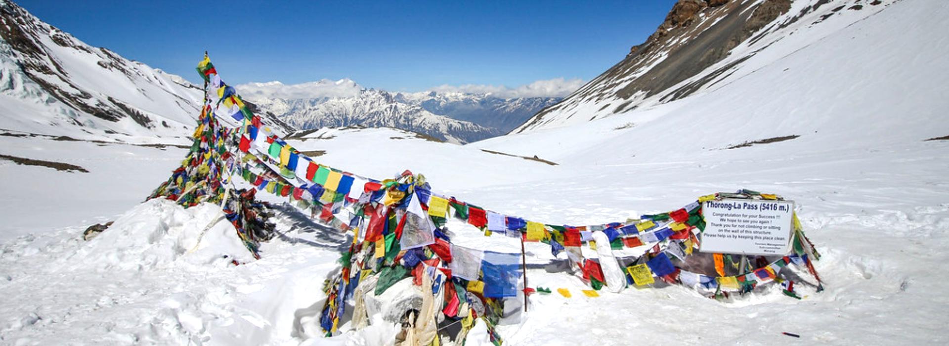
One of the highlights of this trek is passing the Larkya La Pass, a pass that is located above 5,100 meters. It is not an easy climb; however, you will never forget the view that you will enjoy from the top. It is beautiful to be surrounded by such big mountains, which are covered with snow.
After moving into the Annapurna Circuit via a village called Dharapani, the trail then moves into another valley. In this place, the second part of your trip begins. The Annapurna area is more traveled, but full of surprises.
You will pass through pine forests and apple gardens, and wide open valleys. There are homely teahouses and hot meals in villages like Chame, Pisang, and Manang. You will also have time to rest and get used to the altitude before heading to the second big pass, Thorong La, which is at a higher altitude than Larkya La.
After crossing Thorong La, you will reach Muktinath in a few hours, which is a holy place for both Buddhist and Hindu people. It is the beginning of the trail that will take you to Tatopani, where you can drown in natural hot springs and relax your sore legs. This is the final trek that will lead to Ghorepani and Poon Hill, where you will wake up early the next morning to see the sunrise over the Himalayas. It is the climax of a long, beautiful ride.
It is an adventure that will give you an opportunity to explore the lesser-known Nepal and the trails that are also famous. It is not easy, but it is rewarding at the same time. You will be walking through different types of landscapes, including green forests, rocky cliffs, and snowy mountains.
You will know other cultures and get to see how they live in these remote locations. Most importantly, you will also be proud of yourself because you have accomplished something that very few people get the opportunity to.
- Safety first, always
- Best prices guaranteed
- Expert travel team
- Easy booking, no extras
- Customize your journey
Based on 10 reviews

Trip Highlights
- Cross two iconic high passes: Larkya La and Thorong La.
- Witness the beauty of the Mt. Manaslu and Annapurna ranges.
- Explore remote Tibetan villages.
- Spot Himalayan wildlife like blue sheep, yaks, and rare birds.
- Relax in Tatopani’s natural hot springs.
- Visit the sacred Muktinath Temple.
- Scenery from the lakeside with mountain reflections.
Photo and Video Gallery


Manaslu Trek with Annapurna Circuit – 24 days Detail Itinerary
Day 01: Arrive in Kathmandu
Your journey to the Manaslu trek with Annapurna circuit starts as soon as you land in Kathmandu, the bustling capital of Nepal. There won’t be any hikes today, but it is an extremely important day of orientation, equipment checkups, and mental preparation.
You will have your guide and get the permits. There is also the possibility of going around the city, if you have free time.
Kathmandu is a blend of tradition and busy streets. Rest tonight, and you will continue your journey tomorrow.
Max. Altitude: 1,350m/4,429ft. ()
Accommodation: Hotel
Day 02: Kathmandu to Machha Khola
You leave Kathmandu today, and the 8-9 hours of adventurous journey will bring you to Machha Khola. The highway goes along the river gorges, terraced lands, and occasional villages, giving you a glimpse of rural Nepal.
You will travel down the Trishuli and Budhi Gandaki rivers, gradually moving into the subtropical territory. Machha Khola is a small village along the river with green vegetation and steep hills. And this is where you actually start walking tomorrow.
The best way to conclude the day will be to hear the sound of the running water from your tea house.
Activity: 8-9hrs drive
Max. Altitude: 870m/2,854ft. ()
Meal: B L D
Accommodation: Teahouse
Day 03: Trek From Machha Khola to Jagat
The first day begins with a 23-kilometer walk that you complete with a 5-6 hours of ascent between Machha Khola and Jagat.
\The trail follows the Budhi Gandaki river and crosses suspension bridges, and you will cross through the villages of Khorlabesi and Tatopani.
You will pass through natural hot springs, narrow gorges, and cliffs. The ground is green, along with bamboo bushes and thrilling steps of the rock. Jagat is a beautiful village with stone-paved streets on a hillside, which is the gateway of the Manaslu Conservation Area.
Activity: 5-6hrs trek
Max. Altitude: 1,410m/4,626ft. ()
Meal: B L D
Accommodation: Teahouse
Day 04: Jagat to Deng
The trail is 21km long and this will be completed in 6 to 7 hours, where there is a steady increase in altitude and the path goes from Jagat to Deng.
The trail crosses through terraced fields and subtropical forests across the river multiple times on suspension bridges.
You will pass through villages like Salleri and Philim, where the Buddhist prayer flags and chortens begin to appear.
The scene starts shifting and becomes more of the highland. Deng is a small village in a narrow valley, abandoned and occasionally forgotten, but of Tibetan concern. It will welcome you with the house of stones, the walls of the mani, and the sound of the river in the distance, as well as fresh air.
Activity: 6-7hrs trek
Max. Altitude: 1,860m/6,102ft. ()
Meal: B L D
Accommodation: Teahouse
Day 05: Deng to Namrung
Today you will go from Deng and Namrung, a distance of 19 kilometers, and it will take approximately 7-8 hours. This path leads up and up through pine and oak forests and over the Budhi Gandaki River a few times on various suspension bridges.
The trail passes through lovely villages like Bihi and Ghap, where the Tibetan culture is more obvious; the path is decorated with mani walls, prayer flags, and chortens.
The further you go up, the colder the air and the alpine the landscape is. Namrung is a checkpoint village, also a village of wooden carved houses, a calm monastery, and the perfect views of Himal Chuli and Ganesh Himal. It marks the start of the Nubri Valley, which is culturally diverse.
Activity: 7-8hrs trek
Max. Altitude: 2,628m/8,622ft. ()
Meal: B L D
Accommodation: Teahouse
Day 06: Namrung to Shyala
It is a 5 to 6 hour walk today, which covers a distance of 11 kilometers with a steep height of 870 meters through a trail that takes you to Shyala. It passes through rhododendron trees, barley fields, and villages like Lho and Sho.
This viewing starts with a mesmerising view of Shyala; the sight is of a large glacial valley and the sight of Manaslu, Himal Chuli, and Ngadi Chuli in the surrounding.
Shyala is a village of stone houses and yaks, where you may sleep in a peaceful way, along with the mountainous landscape that is more beautifully seen in the morning.
Activity: 5-6hrs trek
Max. Altitude: 3,575m/11,729ft. ()
Meal: B L D
Accommodation: Teahouse
Day 07: Shyala to SamaGaon
The walk is not that hard today and will be covered over a distance of nearly 15 kilometers in 4-5 hours with a comparatively moderate ascent of 20 meters.
Going from Shyala to Sama Gaon, the road moves along the river and rounds glacial moraines, which offer a great view of the north of Manaslu.
You will pass through birch woods and Yak herding camps, and you will reach Sama Gaon, a cultural masterpiece of the Nubri region.
The village is encircled by ancient monasteries, traditional Tibetan houses and a giant mani wall. It is an acclimatization and side-hiking place on the way to Manaslu Base Camp.
Activity: 4-5hrs trek
Max. Altitude: 3,530m/11,581ft. ()
Meal: B L D
Accommodation: Teahouse
Day 08: Acclimatization Day at Sama Gaon
No major climb will be scheduled on this day; it is a rest day and is required to familiarize yourself with the altitude.
You can take short hikes to the Pungyen Gompa or Birendra Lake, both of which are breathtaking. Pungyen Gompa is a modest monastery, which is located on a ridge overlooking the beauty of Manaslu and the glacier beneath. This glacier-bound lake (Birendra Lake) is bright in its turquoise shade.
Have some time and walk around the village, observe the yaks, or even talk to locals and get to know how they live.
Max. Altitude: 3,529m/11,578ft. ()
Meal: B L D
Accommodation: Teahouse
Day 09: Trek From Sama Gaon to Samdo
The distance of the current day is approximately 16km, which would require 5 to 6 hrs to reach Sama Gaon with an altitude gain of 355m, as you ascend from Sama Gaon up to Samdo. The road goes slowly up through the yak field and juniper trees, up the Budhi Gandaki.
You will pass the intersection of Manaslu Base Camp, and you will be heading towards Samdo, a windswept village a few kilometers away from the Tibetan border. It is the big acclimatization point before crossing the Larkya La Pass and has side hikes to the view points above the pass and the other peaks.
Activity: 5-6hrs trek
Max. Altitude: 3,873m/12,707ft. ()
Meal: B L D
Accommodation: Teahouse
Day 10: Trek from Samdo to Dharamshala
Today’s walk starts at Samdo, leading to Dharamshala (9 to 12 hours in total and 585 meters) on the route. The trail is gradual and is clea,r but passes through a barren alpine land with a view of Samdo mountain and Larkya Glacier.
You will pass over yak herds and ancient-looking huts and fewer trees, along with more wind. Larkya Phedi or Dharamshala is a small station made of stones in which trekkers spend the night before crossing the pass.
This accommodation, and the challenge on the next day, make this stay a memory, as does the mountain surrounding.
Activity: 9-12hrs trek
Max. Altitude: 1,455m/4,774ft. ()
Meal: B L D
Accommodation: Teahouse
Day 11: Dharamshala to Bhimtang via Larkya La Pass
It is a very difficult and beautiful day of the trek. You will climb the whole of Dharamshala up to Larkya La Pass and then down Bhimtang, 25 kilometers, of which 646 meters is up, and 1516 meters down.
The climb up the pass is steep and typically icy, and the views at the top, Manaslu, Himlung, Cheo Himal, and Annapurna II, are spectacular. The path leading to Bhimtang is long and may be tedious, though the landscape is magnificent.
Activity: 9-12hrs trek
Max. Altitude: 5,109m/16,762ft. ()
Meal: B L D
Accommodation: Teahouse
Day 12: Bhimtang to Dharapani
Today’s path goes from Bhimtang to Dharapani and drops 1660 meters over a distance of 26 kilometers within 7-8 hours. This route goes through the rhododendron forest, terraced fields of agriculture, and beautiful villages like Tilije and Gho.
Dharapani is a beautiful village and the junction of Manaslu and Annapurna paths, and it is well-equipped and a combination of trekkers.
It is also a culture shift; the impact of Thakali and Gurung begins to be evident, and the landscape no longer seems so foreign after days in the high alpine.
Activity: 7-8hrs trek
Max. Altitude: 3,720m/12,205ft. ()
Meal: B L D
Accommodation: Teahouse
Day 13: Trek from Dharapani to Chame
This day has an almost 15-kilometer walk that takes 6-7 hrs to climb 680 meters in altitude between Dharapani and Chame. The road goes up the Marsyangdi River towards the top, through pine and oak forests, and the villages of Bagarchhap and Timang.
You will see a glimpse of Annapurna II and Lamjung Himal coming out of the clouds. The capital of the Manang district is Chame, which has a hot shower, a bakery, and a better-established trekking infrastructure. It is a beautiful place to sleep today.
Activity: 6-7hrs trek
Max. Altitude: 2,650m/8,694ft. ()
Meal: B L D
Accommodation: Teahouse
Day 14: Chame to Upper Pisang
The trail starts at Chame to Upper Pisang, 690 meters on 13 kilometers, which takes 6 to 7 hours. It leads to narrower roads and passes by beautiful rocky mountains, thick forests.
The Marsyangdi River will be crossed, and you will ascend Pisang gradually. It is more visible and culturally firmer in Upper Pisang.
The village is designed according to the traditional Tibetan style, and a magnificent monastery crowns the village over the valley.
At this point, you can begin to experience the height again, and the view of Annapurna II and IV is even more remarkable.
Activity: 6-7hrs trek
Max. Altitude: 3,300m/10,827ft. ()
Meal: B L D
Accommodation: Teahouse
Day 15: Trek to Manang via Nawal
It is a scenic 7-8 hours (17 kilometers), 240 meters of gain in elevation as you hike the high route of Nawal between Upper Pisang and Manang.
There are also the beautiful views of Annapurna III, Gangapurna, and Tilicho Peak, which are not crowded and are more beautiful as compared to the lower path. Nawal is a small village with traditional houses, a monastery, which is extremely silent, and one can spend some hours there resting.
Near Manang, the land is flattened, and a wide valley can be seen clearly. It is also a cultural and logistical junction prior to the climb of the Thorong La.
Activity: 7-8hrs trek
Max. Altitude: 3,540m/11,614ft. ()
Meal: B L D
Accommodation: Teahouse
Day 16: Acclimatization Day at Manang
We are having a rest day in Manang today, which is at 3540 meters. This rest is very crucial, though the gain in altitude is not much, in order to acclimatize before crossing Thorong La.
You can decide to do short climbs to Gangapurna Lake or Chongkar Viewpoint, which also have easy ascents and a clear view of Annapurna III, Tilicho Peak, and Marsyangdi Valley.
The background of high mountains, the dry climate, and the houses in Tibetan style make the village a favorite among the trekkers. Use the day to hydrate, rest, and prepare to cross the high Pass.
Max. Altitude: 3,540m/11,614ft. ()
Meal: B L D
Accommodation: Teahouse
Day 17: Manang to Yak Kharka
Today’s walk includes climbing 520 meters above Manang to an 8-kilometer trip that lasts between 4 and 5 hours at the Yak Kharka. The path then leads gradually on through juniper and across the little village of Gunsang.
As you ascend more, you will experience the thinning of the air and the slowing of the pace. Yak Kharka is literally translated as yak pasture. It is a quiet and peaceful, and open place.
The other mountains in the area, including Chulu West, are spectacular, and it is said to be serene with no wildlife. This is among the primary acclimatization spots prior to the Thorong La.
Activity: 4-5hrs trek
Max. Altitude: 4,020m/13,189ft. ()
Meal: B L D
Accommodation: Teahouse
Day 18: Yak Kharka to Phedi
The trail today has a total elevation of 465 meters, beginning with Yak Kharka and ending at Phedi, which requires approximately 4 to 5 hours.
The trail is rough and rocky with the sites of prior landslides in certain places, so people should be careful while walking.
Then you will pass Ledar and cross a wooden bridge over the Jarsang Khola, and then ascend up steeply up to either Phedi or Thorong Phedi. This is at the base of the Thorong La Pass and has easy accommodation for the trekkers as they prepare to take on the day.
Activity: 4-5hrs trek
Max. Altitude: 4,020m/13,189ft. ()
Meal: B L D
Accommodation: Teahouse
Day 19: Trek from Phedi or High Camp to Muktinath
It is the most difficult day of the journey. Between Phedi and Thorong La Pass the elevation change between 891 meters and 1616 meters will take a distance of approximately 15 kilometers, taking between 8 and 9 hours.
It is also ascended early in the morning to avoid strong winds at the pass. It is gradual, uninterrupted, and has snow-trails and beautiful sceneries of Dhaulagiri, Annapurna, and Mustang Valley.
The highest trekking pass in the world is Thorong La. The road to Muktinath is a steep, yet beautiful one, that shocks you with distant views of the valley. Mukhinath is a sacred Hindu and Buddhist place of pilgrimage, which has a permanent fire and 108 water spouts.
Activity: 8-9hrs trek
Max. Altitude: 3,800m/12,467ft. ()
Meal: B L D
Accommodation: Teahouse
Day 20: Drive from Muktinath to Tatopani
Today you will go on a jeep ride in which you will drive to an elevation of 2610 meters in a 6 to 7-hour journey. The highway goes through the Kali Gandaki Gorge, one of the deepest in the world, and makes a stop at Jomsom and Marpha, the apple farms land and the Thakali culture.
Tatopani is a Nepali name for hot water because it has natural hot springs to relax tired muscles. The terraced fields and subtropical vegetation surrounding the village are a contrast with the high alpine terrain that you saw for many days.
Activity: 6-7hrs trek
Max. Altitude: 1,190m/3,904ft. ()
Meal: B L D
Accommodation: Teahouse
Day 21: Trek from Tatopani to Ghorepani
This walk is steep and includes Ghorepani via Tatopani in 6 to 7 hours and 1670 meters of elevation gain. The path ascends up through tropical forests, terraced areas, and the beautiful Magar villages such as Sikha and Chitre.
You will pass through the rhododendron bushes, blooming in spring, and the air is colder at the mountain. Ghorepani is a lively village situated at the top of the hill, which offers an amazing sight of the Annapurna and Dhaulagiri mountain range.
Activity: 6-7hrs trek
Max. Altitude: 2,873m/9,426ft. ()
Meal: B L D
Accommodation: Teahouse
Day 22: Hike to Poon Hill, trek to Hile, and drive to Pokhara
You will wake up early and take an early morning walk to Poon Hill and climb 350 meters in a span of about 1 hour to see the sunrise of Annapurna, Dhauligiri, and Machhapuchre.
After seeing the view to the fullest, you will be back in Ghorepani, and then walk down to Hile with a 1780-meter descent in 6 to 7 hours.
You will pass by a mesmerising rhododendron forest and a rocky walking trail. Your destination will be Hile and then drive to Pokhara. You have a well-deserved rest and have a pleasant evening by the lakeside.
Activity: 7-8hrs trek & 2-3hrs drive
Max. Altitude: 3,208m/10,525ft. ()
Meal: Breakfast
Accommodation: Hotel
Day 23: Pokhara to Kathmandu
Today you take a drive back to Kathmandu from Pokhara. You will take Prithvi Highway, which passes through the rivers and hills. By the same adventurous path you started your journey, you will take to Kathmandu.
Once you arrive in Kathmandu, you will return to your hotel, reenter Kathmandu city, and enjoy a goodbye dinner. It is a moment to recall everything you have accomplished, to share stories, and to bring the memory of the mountain with you.
Activity: 6-8hrs drive
Max. Altitude: 1,350m/4,429ft. ()
Meal: Breakfast
Accommodation: Hotel
Day 24: Final Departure
Your journey in Nepal has come to an end today. Depending on your time before the flight, you may do some last-minute shopping or just go on a walking tour of the heritage sites of Kathmandu.
After spending some weeks in the top of forests, glaciers, and sacred valleys, you leave Nepal with a full heart of memories.
Meal: Breakfast
If our standard itinerary doesn't fully meet your needs, we are happy to tailor it to your specific preferences and requirements.
Includes and Excludes
What’s Included?
- Airport pickup and drop in Kathmandu by private car
- Ground transport from Kathmandu to Machha Khola and from Ghorepani/Dharapani back to Kathmandu (local bus or shared jeep depending on group size)
- Hotel stay in Kathmandu before and after the trek (standard hotel, twin sharing)
- Tea house, local lodge, and homestay accommodation during the trek
- Three meals per day during trekking (breakfast, lunch, dinner)
- Breakfast in Kathmandu hotel
- Licensed and experienced trekking guide for the entire trek
- Porters as required for your group size
- Guide and porter salary, meals, accommodation, insurance, and transport
- Manaslu Restricted Area Permit
- Manaslu Conservation Area Permit (MCAP)
- Tsum Valley Restricted Area Permit
- Annapurna Conservation Area Permit (ACAP)
- Local government and restricted area fees
- Acclimatization days according to the itinerary
- Basic first aid kit carried by the guide
- Trekking equipment if needed (sleeping bag, down jacket, duffel bag, trekking poles – must be returned after trek)
- Trek completion certificate
- All government taxes and company service charges
What is not Included?
- International flights to/from Nepal
- Nepal entry visa fee
- Lunch and dinner in Kathmandu
- Personal expenses such as bottled drinks, snacks, hot shower, Wi-Fi, and charging devices
- Alcoholic drinks and extra beverages
- Personal trekking gear not mentioned above
- Travel insurance (must cover high-altitude trekking and helicopter rescue)
- Tips for guides, porters, and drivers
- Extra accommodation or transport due to road closures, weather, or itinerary changes
- Expenses caused by natural disasters, political issues, strikes, or other unexpected events
- Any service not mentioned in the “What’s Included” section
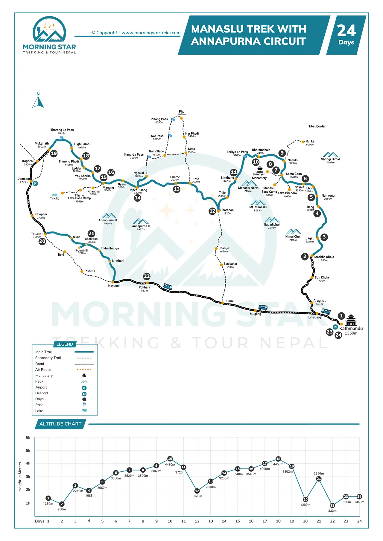
Route Map & Altitude Chart
Trip Information of Manaslu Trek with Annapurna Circuit – 24 days
Best Season to go for Manaslu Trek with Annapurna Circuit
If you are planning to go for the Manaslu trek with Annapurna Circuit trek, spring (March to May) or autumn (September to November) is the best season. These are months where you get that sort of weather where trekking is not only safe but enjoyable. The weather is clear, the temperatures are pleasant, and the big mountain passes, such as Larkya La and Thorong La, are far more manageable to pass.
Spring is the best season to see the mountains, which are lined with rhododendrons that are in blossom, the woods appear fresh, and the villages are bustling with agriculture. The snow starts melting, making the trails less icy, but the mountains remain white and spectacular. It is a joyful experience to walk in the spring because nature shows its colours and power during this season.
Autumn is no less magical than spring and is equally magical. The air becomes cool and the air is clean after the summer rains. The trail looks like a part of heaven, and you have the best glimpses of the Himalayas you can have. It is also the time of year that trekkers come in large numbers globally, and the trails are vibrant. Harvest festivals are celebrated by the local communities, and this makes your trip culturally rich as well.
Winters and monsoons are not ideal decisions. Winter is full of heavy snow and below-zero nights, and the passes might be blocked. Monsoon months are accompanied by rainfall and landslides, and slippery roads. That is why spring or autumn is preferred by most trekkers. It is at this time of the year when you are safest, enjoy the most, and find the most colorful experience.
Permits Required for the Manaslu Trek with Annapurna Circuit
In order to trek the Manaslu trek with Annapurna Circuit, you will require numerous permits, and all of them have their own purpose. In the case of the Manaslu region, the Restricted Area Permit (RAP) is required. Manaslu is near the Tibetan border, and the government continues to control this area due to security and preservation of culture. The RAP makes sure that trekkers are registered, tracked down, and under licensed guides, which is the reason why solitude trekking is prohibited in this area.
The Manaslu Conservation Area Permit (MCAP) is also required with the RAP in this region. This permit funds the Manaslu region in conservation efforts, trail repair, and preservation of vulnerable alpine ecosystems. It assists the local communities in controlling tourism so that it can balance revenue with environmental protection.
As you enter the Annapurna region, the Annapurna Conservation Area Permit (ACAP) is required. It finances waste management, tree planting, and community development initiatives. The absence of this system would lead to the destruction of the environment and the overloading of the local villages by a high number of trekkers.
Lastly, both circuits need the TIMS card ( Information Management System of Trekkers ). It registers your trekking information, which proves useful during emergencies and also makes sure that the trekkers are not lost. These permits are not just for the formalities; they hold the key to safety, conservation, and equitable distribution of tourism benefits.
How Difficult is the Manaslu Trek with Annapurna Circuit
The Manaslu trek with Annapurna Circuit can be categorized as moderate to difficult, primarily due to the many walking days as well as the high-altitude passes, which go above 5,000 meters. Trekkers commonly cover five to nine hours per day, often on steep uphill and downhill walks. The scenery changes continuously; one day it is river-gorge and woodland, the next rocky paths and snowy mountain passes, and this is enough to try endurance and patience.
No professional climbing skills are required, but good physical fitness is essential. Consistent training before the trek, such as running, hiking, or any other form of strength training, will make your body fit for the activity of the trek. Mental fitness is also essential, since the trek will have the simplest of facilities, weather changes, and the necessity to continue moving even when you are exhausted.
Another difficulty during this trek is altitude. The higher you climb, the thinner the air and the harder it is to breathe. This is one of the reasons why we have acclimatization days in the itinerary so that your body will get time to adapt. Most of the trekkers can successfully travel the route as there is proper pacing, hydration, and the leadership of the experienced guides.
This is not a simple journey, but you can make it through with determination, preparation, and respect for the mountains. This is where the struggle lies in the experience as well as the reward. In Outfitter Nepal, we have a group of experienced and certified guides and porters making your journey safer and memorable.
Is AMS a Risk During the Manaslu Trek with Annapurna Circuit?
Yes, Acute Mountain Sickness (AMS) is a real danger in the Manaslu trek with Annapurna Circuit since both trails are located above 5,000 meters. The air is less dense at such altitudes, the oxygen level reduces, and your body cannot adapt to it. The typical symptoms are headache, nausea, dizziness, anorexia, and tiredness.
Some trekkers can be okay at lower altitudes only to find themselves having issues when they are rapidly moving uphill. That is why the itinerary will have acclimatization days in locations such as Sama Gaon and Manang; these allow your body to become accustomed to these heights before you start the big passes.
The most effective solution for avoiding AMS is to hear your body. Slowness in walking, rest intervals, and avoidance of rushing are important. It is also crucial to remain hydrated, but alcohol and smoking should also be avoided as they increase the symptoms.
Consuming light and protein-rich foods is a way to ensure your body is strong. When you experience mild symptoms, take a rest and your body will catch up. In case the symptoms worsen, the easiest way out is to move down as soon as possible to a lower height.
Guides are trained to be able to detect AMS at initial stages and possess first-aid kits. In severe situations, evacuation can be organized, which is why it is essential to have travel insurance that includes high-altitude rescue. Through effective pacing, hydration, and knowledge, the majority of the trekkers can overcome the AMS risks and complete the trek without significant issues.
Can I Trek Solo to the Manaslu Trek with Annapurna Circuit?
In the case of the Manaslu Circuit, the answer is no, you cannot walk alone. The area is considered a restricted area since it is near the Tibetan border, and the government has to ensure that all foreign trekkers have a licensed guide accompanied by at least one companion. This is to keep things safe as well as regulated.
Manaslu trails are remote and not as commercialized, and are usually confusing, so it is not only about keeping the law but also preserving life to be guided. Guides serve as navigators, permit issuers, and mediators between trekkers and the local people. In their absence, there are high chances of being lost and experiencing problems during emergencies.
Solo trekking is technically permitted on the Annapurna Circuit, but is associated with difficulties. The track is quite extensive, and the elevations above 5,000 meters are reached, and the weather is unpredictable.
The freedom in solo trekking may be fine; however, in the presence of guides and porters, there is a lot of value-added. Guides offer cultural knowledge, oversee logistics, and perform health checks at high altitude. Porters are the ones carrying your bags (mostly not more than 20-25 kilograms), and this means that you can carry a day pack and walk around.
So, Annapurna leaves you with a choice of trekking on your own, which Manaslu does not. In those locations where solo trekking can be done, there is a wider and more enjoyable experience with guides and porters about.
How to Prepare for the Manaslu Trek with Annapurna Circuit
Trek Preparation for the Manaslu trek with Annapurna circuit is more than packing a bag; preparing to take a long trip in the Himalayas requires preparation of your body, mind, and plans. It is important to be mentally prepared for a long trip in the Himalayas, and this involves preparation of your body and your mind, along with your plans.
The trek takes weeks, with five to nine hours of walking a day, and the initial step should be stamina building. Your legs and lungs are strengthened with regular exercise like jogging, bicycle riding, or long walks.
It is equally important in mental preparation. The adventure will guide you through isolated villages, simple accommodations, and mountain passes where the climate may vary in a short period of time. You need to be ready to adjust in every way possible during unpredictable circumstances, and spending long days walking will help to make the journey more memorable.
You can also read before you travel about the local culture and geography, which gives some meaning to what you will encounter on the trail. Logistics matter too. Make sure you have high-altitude trekking and emergency evacuation travel insurance.
Get all the necessary permits to avoid unnecessary time wastage at the checkpoints by obtaining them in advance, preferably by a registered agency like Outfitter Nepal. Get your equipment ready with good boots, a lot of clothes, and a warm sleeping bag will all help you out.
Lastly, plan to go on Manaslu Trek with Annapurna Circuit Trek. There is no need to hurry the trek, but the acclimatization days in Sama Gaon and Manang do not go in vain. Being respectful to the altitude, attentive to your body, and taking the suggestions of your guide will ensure that you will be safe. This is not only a trek that is possible but also a richly rewarding trek with the right preparation.
Things to Pack for the Manaslu Trek with Annapurna Circuit
The packing of the Manaslu Trek and Annapurna Circuit trek is all about choosing the right balance between comfort and realism. You will be carrying your bag around for several weeks in various weather conditions, so nothing in your bag should be without a purpose.
A good pair of trekking boots is the most important. They must be strong, waterproof, and presumably worn in before the trek sets in. Besides boots, also carry comfortable sandals or light shoes in case you wish to rest your feet during the evenings in the lodges.
The dresses should be worn in layers, which allows you to adapt to all temperatures. Begin with moisture-wicking base layers, then wear wool or warm fleece, and finally a waterproof jacket to keep off rain or snow.
When it is warmer than 3,500 meters on a cold night, a down jacket would be required, and trekking pants and thermal leggings will also keep you warm and free. Gloves, a warm hat, and sunglasses should not be forgotten to protect from the mountain sunshine.
A sleeping bag is also one of the essentials. A sub-zero sleeping bag with four seasons will be very comfortable in the lodges, where you might have blankets that might not be sufficient for your preference. When climbing steep hills, trekking poles are used to assist in a steady rising or falling, and a headlamp in the early morning or dark lodge rooms.
Sunscreen, lip balm, and water purification tablets can also be counted among other necessities, as bottled water is costly and not environmentally friendly. A power bank will have your devices charged, and you will need to carry some Nepalese Rupee cash as there are no ATM on the trail. Light but not heavy, all your possessions must make your walk easier, colder, or safer.
Is insurance required during the Manaslu Trek with Annapurna Circuit?
The Manaslu trek with Annapurna Circuit must be insured. Insurance has now become mandatory by the government before the issuance of permits. This was implemented because high mountain trekking involves actual danger, like altitude sickness, spontaneous weather shifts, landslides, or injuries on outlying routes.
The Restricted Area Permit to Manaslu is not available without insurance, and even in case you attempt it, you would be putting yourself at risk.
Emergency evacuation is the most dangerous threat. The idea of helicopter rescue is a common one in Nepal, yet it is very costly, in most cases, in the thousands of dollars. Insurance will cover these expenses, including the treatment in Kathmandu hospital, in case it is necessary. It will also save you money in case your trek has to be shortened because of sickness or accidents.
Getting insurance is simple. It can be organized online before coming to Nepal or by means of the travel agencies that deal with trekking packages. All you need to do is ensure that your policy has high-altitude trekking with 5000 meters and has helicopter rescue. Most of the general travel policies do not cover such specific risks, hence you need to read the details properly.
The insurance is not just a sheet of paper. It provides you, your guide, and your family back home with peace of mind. Hiking in the Himalayas is not only an adventure, but it is also supposed to be safe. When you are well insured, you will be able to experience the journey without any worries that something will go wrong, and with will not know how to get help.
How Safe is the Manaslu Trek with Annapurna Circuit?
The Manaslu trek with Annapurna Circuit is believed to be very safe when one is properly prepared, has permits, and guides. Each year, thousands of trekkers go through these routes, and the paths are well developed with tea houses, checkpoints, and local communities along the pathways.
The system incorporates safety measures in places like Jagat and Dharapani, where there is a permit check as well, in Manaslu, guides are mandatory, and conservation offices watch the trekking business. This shows that trekkers are rarely untracked.
Licensed guides and porters are one of the primary factors that make the trek safe. Guides receive training to identify the first indicators of altitude sickness, logistics, and problematic travel routes of the trail.
Porters minimize physical effort by carrying your heavy loads, and this will decrease the threat of fatigue and harm. They combine their efforts to ensure that the trekkers do not have to worry about the trek anymore.
Safety is also ensured by the infrastructure. Tea houses offer shelter, food, and some small medical assistance. Trekkers are always close to the trail villages, which are welcoming enough that support is not far. The limited communications systems are getting better, and in the event of a disaster, satellite phones or local SIM cards can be used.
Most Asked Questions
- Safety first, always
- Best prices guaranteed
- Expert travel team
- Easy booking, no extras
- Customize your journey
Based on 10 reviews
Have Questions?
+977 9767224414