Have Questions?
+977 9767224414Unmissable holidays deals - Save up to 20%
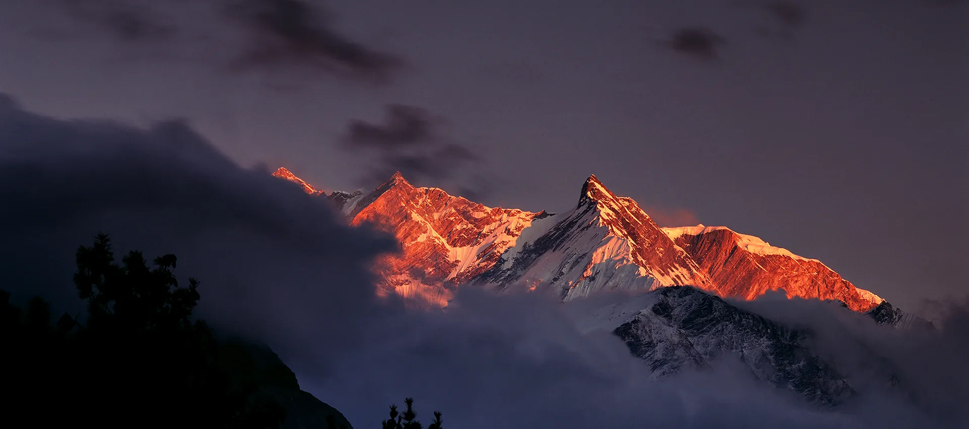
Sherpani Col Pass Trek – 22 Days
Duration
22 Days
Trip Difficulty
Moderate
Max. Altitude
6,190m
Destination
Nepal
Group Size
2-20 People
Accommodation
Hotel, Teahouse
Transportation
Flight
Meals
B L D
Explore more facts about the trip
Overview of Sherpani Col Pass Trek – 22 Days
The Sherpani Col Pass Trek is an extremely difficult yet rewarding high-altitude trekking experience in Nepal, which is aimed at dedicated trekkers wanting to have a genuine Himalayan experience. It is an amazing expedition that links the distant Makalu area with the renowned Everest area, passing through rocky glaciers, scenic mountain ranges, secluded valleys and stunning alpine scenery. This adventure, in contrast to the traditional routes of teahouse trekking, is a blend of traditional trekking and expedition-like travel and is an exclusive experience for those who want something more challenging and far off.
The trek typically starts with a flight from Kathmandu to Tumlinghar and then a trip to Num, where the trekking trip begins. The trail meanders slowly through picturesque mountain villages, terraced agricultural land, thick forests, alpine meadows, and the wild, untouched Makalu Barun National Park. The scenery is getting more dramatic as the trek continues, with the spectacular scenes of the Himalayan peaks and glacial valleys.
One of the best parts of the trip is to have Makalu Base Camp (4,870 m / 15,978 ft), where trekkers are directly under the face of the world’s fifth-highest mountain, Makalu. The adventure then gets more technical with crossings of glaciers, tented camping, and climbing gear. The expedition climaxes at Sherpani Col at (6,190 m / 20,308 ft) and then another thrilling m over-Amphu Lapcha Pass at (5,848 m / 19,186 ft).
The Sherpani Col Pass Trek Itinerary through Amphu Lapcha Pass is a physically challenging one, and it demands a high fitness level, prior experience in trekking, and proper acclimatization. The rewards, however, are extraordinary, spectacular views of Everest, Makalu, Lhotse, Kanchenjunga, Ama Dablam, Baruntse, and a host of other Himalayan giants.
This is a perfect adventure holiday destination for individuals who desire more than a typical trekking holiday. Trekking through the high altitudes is one of the most memorable experiences in Nepal, and through the skillful planning and assistance of seasoned operators, such as Morning Star Trek, the trekkers will go through the journey safely.
- Safety first, always
- Best prices guaranteed
- Expert travel team
- Easy booking, no extras
- Customize your journey
Based on 10 reviews

Trip Highlights
- Pass the tricky Sherpani Col at (6,190 m / 20,308 ft), the summit of the trail.
- Cross the exciting Amphu Lapcha Pass at (5,848 m / 19,186 ft).
- Visit spectacular Makalu Base Camp at (4,870 m / 15,978 ft)
- Hike in Makalu Barun National Park wilderness.
- See the spectacular scenery of Everest, Makalu, Lhotse, Kanchenjunga, Ama Dablam, and Baruntse.
- Have a taste of both conventional teahouse hiking and out-of-the-way expedition camping.
- Trek through quaint Sherpa towns, alpine valleys, glaciers, and steep mountain passes.
- Hike one of the most sought-after and challenging trekking trips in Nepal.
Photo and Video Gallery


Sherpani Col Pass Trek – 22 Days Detail Itinerary
Day 01: Arrival at Kathmandu Airport
Greetings, Nepal, where your Sherpani Col Pass adventure begins. On reaching Tribhuvan International Airport, we will receive you and will take you to your hotel in Kathmandu. The capital of Nepal is located at (1,300 m / 4,265 ft) and is a bustling place to experience first, having vibrant streets, colorful markets, and a historic environment. Once you have checked in, you may unwind after your international trip or have a simple stroll around the immediate neighborhood to feel the city life.
It is an off day where people will rest and revive before the expedition. The following day, you will have a meeting with your trekking guide to have a complete trip briefing and preparation session. Today, spend the night in Kathmandu and then proceed to the mountains.
Activity: Arrival in Nepal, 30 min
Max. Altitude: 1,300m/4,265ft. (Kathmandu)
Meal: Breakfast
Accommodation: Hotel
Day 02: Official Procedure and Preparation Day
The day is devoted to last-minute preparation, and then the trek starts. The group will have a briefing about the Sherpani Col Pass Trek. After breakfast, your guide will meet the group, introduce everyone, and give a detailed briefing. Trekking gear will be inspected, and the guide will assist in getting any missing equipment borrowed or bought. Relevant travel documents will also be received to process a permit.
Then, you will have some sightseeing around Kathmandu at (1,300 m / 4,265 ft) and explore the most popular sites such as Monkey Temple, Boudhanath, Pashupatinath, and Basantapur Square. It is an excellent chance to learn the culture of Nepal prior to traveling to the inaccessible mountains. The day is casual yet significant in terms of preparation. It is advisable to get a good sleep before the journey east on the other side.
Activity: Preparation Day, Full day
Max. Altitude: 1,300m/4,265ft. (Kathmandu)
Meal: Breakfast
Accommodation: Hotel
Day 03: Fly from Kathmandu to Tumlingtar, then drive to Num
Your mountain adventure starts with a scenic flight from Kathmandu to Tumlingtar, the route normally takes about 35 to 40 minutes. The mountain views can be seen during the flight, depending on weather conditions. On arrival, your trekking crew will welcome you and assist with the transportation of baggage. You are going to carry on by road, through the Arun Valley, one of whose villages, rice terraces, and subtropical sceneries you will pass.
The drive passes by locations like Khandbari and Hururu, and arrives at Num at (1,560 m / 5,118 ft). Num is a tiny hillside village and the entry point to your hiking path. You can check into a local teahouse, where you can have some rest and prepare for your first trekking day tomorrow.
Activity: Flight / Drive, 5-6 hours
Max. Altitude: 1,560m/5,118ft. (Num )
Meal: Breakfast, Lunch, and Dinner
Accommodation: Teahouse
Day 04: Trek to Seduwa
The first day of trekking is today. You start walking in the ridges of mountains and farmlands after having breakfast in Num towards the valley of the Arun River. The path initially leads down the steep terraced fields and village lanes, then to the suspension bridge over the river Arun. This sloping part should be well-footed. Once across the river, the trail turns into a steady climb uphill to Seduwa.
On the path, Makalu Barun National Park permits are inspected when you formally enter the guarded area. The next stop is Seduwa (1,500 m / 4,921 ft), where you will stay overnight in a local teahouse. Today is a mixture of both high downhill and uphill, and a physically engaging, yet fruitful, introduction to the trek.
Activity: Trekking, 5-6 hours
Max. Altitude: 1,500m/4,921ft. (Seduwa)
Meal: Breakfast, Lunch, and Dinner
Accommodation: Teahouse
Day 05: Trek to Tashi Gaon
The path today, after breakfast, leads further into the Makalu territory. The trail goes northwestward along the ridges between the Isuwa Khola and Kasuwa Khola valleys. The trail moves through agricultural fields, villages and picturesque terraced hills, providing a calm walking day with a magnificent mountain environment. Before Tashi Gaon at (2,100 m / 6,890 ft), you will pass by Navagaon and Kharsing Kharka.
It is one of the last of the permanent villages on the road before the high mountain wilderness commences. As the walk is shorter today, you will have time to rest and look about the village on arrival. The increase in altitude is also gradual, and your body starts to adapt to the elevation rise in the future.
Activity: Trekking, 4-5 hours
Max. Altitude: 2,100m/6,890ft. (Tashi Gaon)
Meal: Breakfast, Lunch, and Dinner
Accommodation: Teahouse
Day 06: Trek to Khongma Danda
It is one of the initial strenuous climbing days of the trip today. You leave Tashi Gaon after breakfast and begin a long walk up a mountain range, through forested tracks and mountain ridges. After a few hours, you arrive at Dhara (2,867 m / 9,406 ft), where you may have a brief rest. Then the trail goes up with more and more alpine scenery, with dense vegetation slowly disappearing into the rocky mountainous scenery.
You pass Unshisha at (3,200 m / 10,499 ft) before the final steep climb to Khongma Danda at (3,500 m / 11,483 ft). This is a difficult day of trekking due to the great increase in altitude, and hence a slow pace is significant. After arriving at Khongma, you are able to have a rest and enjoy the high-altitude mountain environment, which is much cooler.
Activity: Trekking, 6-7 hours
Max. Altitude: 3,500m/11,483ft. (Khongma Danda)
Meal: Breakfast, Lunch, and Dinner
Accommodation: Teahouse
Day 07: Acclimatization Day
It is a crucial acclimatization day at Khongma Danda. A good rest and exercise enable your body to acclimate itself to the lighter air before ascending to the higher mountains. You can either rest at the teahouse, admire the scenery around, or have a short acclimatization hike. A walk to Kauma La Pass (3,603 m / 11,821 ft) is suggested which is about 1 hour.
Hiking at high altitude is helpful to assist in adaptation and minimize the chances of altitude sickness. The day is planned as being less demanding, to enable time to recuperate after the steep climb yesterday. This practice is necessary as there are more challenging mountain passes and much greater altitudes to come in the days ahead.
Activity: Short Hike / Rest Day, 2-4 hours
Max. Altitude: 3,603m/11,821ft. (Kauma La Pass)
Meal: Breakfast, Lunch, and Dinner
Accommodation: Teahouse
Day 08: Trek to Mumbuk (Dobato) via Shipton La Pass, Keke La Pass, and Tutu La
It is one of the most difficult trekking days to date, and we have already made several crossings of high passes. You start with a very early breakfast, and proceed to ascend through rhododendron wood to Kauma La, and thence along the ridge. Depending on the conditions, the trail could be snowy. You pass Shipton La (4,125 m / 13,533 ft) (named after Eric Shipton), then descend to Kalo Pokhari Lake before ascending again to Keke La.
It proceeds onward through Tutu la at (4,075 m / 13,369 ft) and down into the pine forest into Mumbuk in the Barun Valley. All day long, you can have dramatic scenery of Makalu, Chamlang, and other mountains. It is a long, physically challenging day of continuous up and down and mountainous terrain.
Activity: Trekking. 7-8 hours
Max. Altitude: 4,170m/13,681ft. (Shipton La)
Meal: Breakfast, Lunch, and Dinner
Accommodation: Teahouse
Day 09: Trek to Yangla Kharka
The track then leaves Mumbuk and runs downwards to Yangla Kharka. The modern path runs along the river on the southern bank of the river through rough and isolated land. You will pass a bridge and move on through areas of landslides, with the path perhaps rocky and irregular. Careful walking is important in these areas.
As the path continues, the valley starts to widen, exposing a gorgeous alpine landscape comprising grassy fields, wild flowers, trees with lichen and random boulders. After some time, you reach Yangla Kharka at (3,557 m / 11,670 ft), a quiet mountain pasture. Today is not as demanding as it was the previous day, though it still involves trekking over natural terrain, and it is still remote.
Activity: Trekking, 5-6 hours
Max. Altitude: 3,557m/11,670ft. (Yangla Kharka)
Meal: Breakfast, Lunch, and Dinner
Accommodation: Teahouse
Day 10: Trek to Langmale Kharka
The present trail leads farther into the Barun Valley. You proceed north along the Barun River, through picturesque alpine scenery, after breakfast. You will come to Nghe Kharka, where there is a little monastery. The route then ascends to the pine forest and Yak Kharka and Merek Camp at (4,010 m / 13,156 ft). Following a rest, the path proceeds in a leisurely climb, over little streams, and a bridge made of wood over the Barun River.
With the rise in elevation, forests are slowly being wiped out and replaced by open grassy fields. And, at last, you arrive at Langmale Kharka (4,410 m / 14,469 ft), where rustic teahouses offer an overnight refuge. It is picturesque today because of the beautiful views of the surrounding Himalayan peaks.
Activity: Trekking, 4-5 hours
Max. Altitude: 4,410m/14,469ft. (Langmale Kharka)
Meal: Breakfast, Lunch, and Dinner
Accommodation: Teahouse
Day 11: Trek to Makalu Base Camp
Today, you hike into a high-altitude Alpine Makalu Base Camp. After breakfast, leaving Langmale Kharka, the trail takes off through sandy and rocky regions with the lower Barun Glacier slowly appearing into view. You will arrive at Shershong pasture (4,650 m / 15,256 ft) and follow the Barun River, then over a wooden bridge.
From there, the route leads to Makalu Base Camp at (4,870 m / 15,978 ft). It is a region of spectacular mountainous terrain, with the tall pyramid of Mount Makalu taking center stage. The remote location notwithstanding, there are warm lodges where people can stay over. The day entails gradual walking of heights, and thus a slow pace will be crucial. One of the key milestones of the expedition is to arrive at base camp.
Activity: Trekking, 5-6 hours
Max. Altitude: 4,870m/15,978ft. (Makalu Base Camp)
Meal: Breakfast, Lunch, and Dinner
Accommodation: Teahouse
Day 12: Acclimatization Day at Makalu Base Camp
It is the second day of acclimatization to equip your body to reach greater heights in the future. You can rest in camp, or you can go on an acclimatization hike to a local viewpoint. When you take the hike, you pass over the Barun Glacier River and ascend slowly up the eastern ridge of Makalu. It ascends at a steeper rate than it levels off towards a plateau around (5,220 m / 17,126 ft). It is a place where one can enjoy incredible views of Makalu, Peak 3, Everest, and Lhotse.
This brief increase is useful to enhance the altitude adjustment and maintain physical efforts within reasonable limits. Once at the viewpoint, you go back to Makalu Base Camp, where you have a rest, food, and rest before proceeding to the more technical mountain phases of the expedition.
Activity: Rest day / short hike, 3-5 hours
Max. Altitude: 5,220m/17,126ft. (Makalu Base Camp)
Meal: Breakfast, Lunch and Dinner
Accommodation: Teahouse
Day 13: Trek to Swiss Camp
Today, you walk out of Makalu Base Camp and into a more remote expedition field. The path goes west along the moraine on the Barun Glacier, and Makalu can be seen well along the route. The surface becomes more rugged, and the rocky surfaces, ice and jagged glacier side trails present difficulties in moving around. The higher you go, the more dramatic and isolated the surroundings are.
Finally, you come to Swiss Camp (5,150 m / 16,896 ft), where you will set up tents that will serve as overnight accommodation. This is the start of the more technical portion of the expedition. In the afternoon, your guide will give you a practical lesson on the use of crampons, harnesses and fixed ropes, which will prepare you to face the difficult pass crossings ahead.
Activity: Trekking, 5-6 hours
Max. Altitude: 5,150m/16,896ft. (Swiss Camp)
Meal: Breakfast, Lunch and Dinner
Accommodation: Teahouse
Day 14: Trek to Sherpani Col Base Camp
Today, you are nearer to the climax of the expedition. You move on post breakfast out of Swiss Camp, heading to Sherpani Col Base Camp. The trail is steep and rocky; glacier climbing needs to be consistent and regenerating. The further up you go, the more rugged and entirely alpine the environment becomes. And finally, you arrive at Sherpani Col Base Camp at around 5,690 m / 18,668 ft, and a tent will be pitched amidst little glaciers.
This is a day of little distance, but hard physical work, due to the elevation and the rugged ground. Once there, you will be able to rest and re-examine technical equipment again, such as crampons and harnesses, before the big crossing of Sherpani Col, the highest and most difficult part of the trek, the next day.
Activity: Trekking, 5 hours
Max. Altitude: 5,690m/18,668ft. (Sherpani Col Base Camp )
Meal: Breakfast, Lunch, and Dinner
Accommodation: Teahouse
Day 15: Trek to Honku Basin via Sherpani Col and West Col
Today is the most technical and strenuous of the whole expedition. You will rise in the morning at 3:00 AM and start walking in the dark, having packed your equipment. The path begins on a glacier, for which crampons and harnesses might be necessary. Sherpani Col (6,190 m / 20,308 ft) is the summit of the trek and is reached by a steep climb with fixed ropes.
The highest point is the spectacular views of Makalu, Everest, Lhotse, Kanchenjunga, Ama Dablam, and many other peaks. The route is steep and technical, crossing the West Barun Glacier and the ascent on West Col, and then downward to the Honku Basin. It is a long, weary day over alpine country by a remote road which demands absolute concentration and stamina.
Activity: Highest pass, Sherpani Co, 10-12 hours
Max. Altitude: 6,190m/20,308ft. (Sherpani Col)
Meal: Breakfast, Lunch and Dinner
Accommodation: Teahouse
Day 16: Trek to Amphu Lapcha Base Camp
Following the strenuous crossing of yesterday, today proceeds over the remote high-altitude Honku country. The path runs along the small Honku Glacier valley, with the impressive mountainous landscape. You slowly approach the west side of the Kang Leyamura, and as you pass, you see a little lake of glacial ice. The trail continues to ascend gradually to Panch Pokhari, the Five Lakes of the Alps, a lovely snow-white alpine region, encircled by snow-white mountains.
As you pass through the north side of the lakes, you ultimately arrive at Amphu Lapcha Base Camp (5,527 m / 18,133 ft). The high elevation and rugged terrain, though not as technical as the previous day, make this a tough trekking day. The scenes of glaciers and distant Himalayan vistas are worth the effort.
Activity: Trekking, 6-7 hours
Max. Altitude: 5,527m/18,133ft. (Amphu Lapcha Base Camp)
Meal: Breakfast, Lunch, and Dinner
Accommodation: Teahouse
Day 17: Climb over Amphu Lapcha Pass to Chhukung
It is a second crossing of a high-pass, and one of the most adventurous days of the trip. You start climbing up steep glacial terrain after breakfast to the Amphu Lapcha Pass. It contains technical parts that are fixed with ropes, and the jumar equipment can be used. Upon arriving at the pass at (5,848 m / 19,186 ft), astonishing panoramas unfold around the Himalayan giants surrounding it, such as Everest, Lhotse, Makalu, Baruntse, Island Peak, and Ama Dablam.
The route is sharp and technical, and should also be done with the help of fixed ropes and cautious steps. The path then trails down to the Baruntse Glacier and a glacial lake and then to Chhukung at (4,720 m / 15,486 ft). Today is a mixture of technical climbing, glacier travel, and amazing mountain scenery.
Activity: High Pass, 9-10 hours
Max. Altitude: 5,848m/19,186ft. (Amphu Lapcha Pass)
Meal: Breakfast, Lunch and Dinner
Accommodation: Teahouse
Day 18: Trek to Pangboche
Today, you will start your trek to Pangboche. The route is less technical when you enter the old-fashioned Everest trekking area. After taking breakfast at Chhukung, you drop down the valley of Imja Khola, through the alpine scenery and small villages such as Orsho and Shomare. You soon arrive at Dingboche and proceed down to Pangboche. In between, we are always accompanied by the beautiful scenery of Ama Dablam and Taboche Peak.
The path is not as tough as the earlier mountain crossings, which are high in the mountains, and this gives time to appreciate the scenery and the changing landscape. Pangboche is located at (4,260 m / 13,976 ft) and has a historic monastery. This is the shift in the expedition-style trekking to the more comfortable and familiar Everest trekking route with the villages.
Activity: Trekking, 5-6 hours
Max. Altitude: 4,720m/15,486ft. ()
Meal: Breakfast, Lunch, and Dinner
Accommodation: Teahouse
Day 19: Trek to Namche Bazaar
Then, after breakfast, you leave Pangboche and go towards Namche Bazaar. The trail then runs by Debuche to the well-known Tengboche Monastery area. At this point, there is a sharp downward slope that extends to Phungi Thanga at (3,250 m / 10,663 ft), and then another upward slope is taken to Sanasa. At Sanasa, the path forks off to Gokyo or Namche Bazaar.
You are on the path to Namche, where you see beautiful mountain scenery and have frequent glimpses of Everest, Lhotse, Ama Dablam, and Thamserku. The busy Sherpa trading hub of the Khumbu region is Namche Bazaar (3,440 m / 11,286 ft). This is a more comfortable day of trekking than in recent days with well-laid-out trails, villages, and better facilities.
Activity: Trekking, 5-6 hours
Max. Altitude: 3,440m/11,286ft. (Namche Bazaar)
Meal: Breakfast, Lunch, and Dinner
Accommodation: Teahouse
Day 20: Trek to Lukla
It is the last day of the trek of your expedition. Breakfast is served, and you walk out of Namche Bazaar and up the steep slopes to the meeting point of the rivers Dudh Koski and Bhote Koski to Lukla. The path crosses suspension bridges and then stretches into pine trees and ancient mountain villages such as Jorsalle, Monjo, and Benkar before heading to Phakding. The trek is then resumed after a brief pause in Ghat, Thado Koshi, Chheplung, and Chaurikharka.
The last ascending part will take you to Lukla at (2,830 m / 9,285 ft). Your mountain trekking career is officially over. The day is physically active, despite the lower altitude, with numerous ups and downs. Tonight is the time to rejoice at the accomplishment of this impressive Himalayan adventure.
Activity: Trekking, 5-6 hours
Max. Altitude: 3,440m/11,286ft. (Namche Bazaar)
Meal: Breakfast, Lunch, and Dinner
Accommodation: Teahouse
Day 21: Fly from Lukla to Kathmandu
You give up the mountains after breakfast and embark on a picturesque domestic flight back to Kathmandu from Lukla. The air journey typically lasts approximately 35 minutes and provides the last opportunity to view the Himalayan sceneries at elevation, provided the weather is good. When you get to Kathmandu (1,300 m / 4,265 ft), you will be taken to the hotel.
This is a welcome break after several days of trekking in isolated areas of the mountain range, a hot shower, a sightseeing day, or a trip to the mall to buy souvenirs. This will be your official stop for the trekking part of your Sherpani Col Pass adventure. Spend your last night in Nepal pondering over the unbelievable scenery, difficult routes, and the memorable moments of the trip.
Activity: Flight, 35 mins
Max. Altitude: 2,830m/9,285ft. (Lukla )
Meal: Breakfast
Accommodation: Hotel
Day 22: Departure from Nepal
Your adventure of the Sherpani Col Pass ends today. Our crew will pick you up after breakfast at your hotel and take you to Tribhuvan International Airport, where you will board your flight, depending on the time of your international flight. Kathmandu is still at (1,300 m / 4,265 ft), a dramatic change to the extreme heights you had been at during the expedition. It is a mere day of departure and has time to bid Nepal a farewell to an amazing journey in the Himalayas.
From cultural urban experiences to isolated glaciers, technical mountain passes, and amazing panoramas, this trek makes great memories. We wish you a nice journey, a safe and successful one, and that Nepal will leave you with many memories to last until your next adventure.
Activity: Departure
Max. Altitude: 1,300m/4,265ft. (Kathmandu)
Meal: Breakfast
If our standard itinerary doesn't fully meet your needs, we are happy to tailor it to your specific preferences and requirements.
Includes and Excludes
What’s Included?
- Airport transfers by car (in and out) in private vehicles.
- Domestic flight Kathmandu-Tumlingtar.
- Domestic flight Kathmandu-Lukla.
- Ground transportation (private) between Tumlingtar and Num.
- Hotel accommodation in Kathmandu, 5-star as per itinerary.
- Teahouse accommodation on the days of the trek when it was possible.
- Accommodation in tents in remote parts of the expedition.
- Three meals daily in the trek (breakfast, lunch, and dinner) as per the itinerary.
- Breakfast in Kathmandu as indicated in the itinerary.
- English-speaking trekking guide (professional).
- Qualified trekking staff.
- Porter service to carry luggage.
- Makalu Barun National Park permit and other required permits
- High pass crossing technical support.
- Group climbing equipment, such as fixed ropes, where needed
- Simple first aid assistance.
- Exploring Kathmandu on preparation day.
- All taxes and service fees by the government.
What is not Included?
- Airfare between Nepal and other countries.
- Nepal entry visa charges.
- Comprehensive travel insurance
- Evacuation of helicopters in emergencies.
- Personal trekking gear and gear.
- Additional hotel stay in Kathmandu because of the delays.
- Lunch and dinner in Kathmandu unless indicated.
- Personal costs like laundry, Wi-Fi, charging, hot showers, snacks, and beverages.
- Usage: Alcohol and bottled drinks.
- Tips to guide, porter, and support staff.
- Personal medical expenses
- Rescue costs which are not insured.
- The additional transport as a result of itinerary changes or cancellation of flights.
- Any other services not listed in the includes section.
Trip Information of Sherpani Col Pass Trek – 22 Days
Best Season and Weather
The best time for the Sherpani Col Pass Trek is during spring (March to May) and autumn (September to November). These seasons tend to have more favorable weather conditions, clearer skies, and better mountain views. The lower altitude rhododendron forests are in the spring, and the dry trails and perfect visibility of the fall are a hallmark of the autumn season. This trek goes to extremely high altitude, as high as Sherpani Col at (6,190 m / 20,308 ft), and the weather may shift rapidly even during the most favorable seasons.
During winter, there is a lot of snow, and the cold is excruciating, whereas during the monsoon season, there is slipping paths and a lack of visibility. To make the Sherpani Col Pass Trek through the Amphu Lapcha Pass the safest and most enjoyable, it is highly important to select the right season.
Difficulty
The Sherpani Col Pass Trek Itinerary is regarded as a high-altitude expedition trek that is very difficult. It is a combination of long walking days, glacier route, ascending heights, technical rope work, and numerous high mountain crossings. Sherpani Col (6,190 m / 20,308 ft) is the peak and Amphu Lapcha (5,848 m / 19,186 ft) is the peak, and this is physically and mentally challenging. The crampons, harnesses, and use of fixed ropes are necessary in other sections, particularly when crossing the difficult passes.
It is highly advised that one has previous high-altitude trekking experience. The Sherpani Col Pass Trek via Amphu Lapcha Pass is not an easy trek to do without mountain experience. Good stamina, off-road confidence, and cold and long-day capabilities are all musts in completing this adventure safely.
Altitude Sickness
The main problem with the Sherpani Col Pass Trek is altitude sickness due to several days of climbing way above (5,000 m / 16,404 ft) in the Sherpani Col Pass. The typical symptoms are headache, nausea, dizziness, fatigue, insomnia, and dyspnea. Acclimatization should be performed properly to mitigate risk. There are scheduled acclimatization days in the program to allow your body time to adapt. Remaining hydrated, maintaining a moderate pace, and informing about the symptoms are part of the safety measures.
The extreme altitude disease is life-threatening when neglected. The Sherpani Col Pass Trek through the Amphu Lapcha Pass is associated with extreme altitude, and therefore, trekkers must be aware of the dangers of the altitude before they set off. An experienced guide in high altitude trekking can be used to keep an eye on your status during the expedition.
Preparation and Fitness
The Sherpani Col Pass Trek requires good physical preparation. The expedition involves days of trekking, crossing glaciers, mountaintop ascents, and extreme mountain weather. The process of training must start several weeks or months prior to departure. Emphasize cardio activities such as hiking, running, cycling, or climbing stairs to enhance endurance. Leg, core and general stamina can also be trained.
Experience in trekking at high altitudes is a great benefit, particularly over 4,000 m / 13,123 ft. Mental preparation is also essential since there are long and difficult days. The Sherpani Col Pass Trek via Amphu Lapcha Pass is a physically challenging, patient, and determined expedition through a technical landscape, varying weather, and isolated expedition-like trekking circumstances.
Food and Accommodation
The Sherpani Col Pass Trek has food and accommodation according to the location. At low and middle-altitude villages, trekkers are accommodated in local teahouses, which have basic and comfortable rooms. Foods typically consist of rice, noodles, soup, potatoes, eggs, tea, and local, straightforward foods. Facilities are made simpler as the route gets higher. At Makalu Base Camp (4,870 m / 15,978 ft), there is limited and available accommodation.
Tented camping is necessary in the expedition parts around Swiss Camp and Sherpani Col Base Camp. In remote high-altitude regions, food is simplified as there are very few supplies. Morning Star Trek can assist in coordinating logistics, which means accommodating and arranging meals during this strenuous route of expeditions.
Transportation
The Sherpani Col Pass Trek is typically preceded by transportation from Kathmandu and then some domestic flight to Tumlingtar. Trekking to Num, the starting point of the trek, involves a long road trip, which starts in Tumlinghar. Upon the completion of the expedition, the path leaves via Lukla, and a domestic plane gets back to Kathmandu. Sometimes flights in Nepal are delayed due to weather conditions, particularly in the mountainous areas. Ground transportation can be done by private vehicles based on the itinerary.
The logistics of transportation are more complicated than usual trekking trails since this trek is concentrated in remote eastern Nepal and the Everest region. To help with the overall Sherpani Col Pass Trek experience, Morning Star Trek will help with flights, airport transfer, and local transport planning.
Communication
Communication in the Sherpani Col Pass Trek is more restricted as one gets deeper into the mountains. Some of the lower villages may have mobile network coverage, but higher elevations will result in the loss of signal strength or even loss of coverage altogether. Where the internet is provided, the speed is normally slow and might need additional charges at certain teahouses. Above Makalu Base Camp (4,870 m / 15,978 ft), there are no communication possibilities in the expedition areas.
Trekkers must not anticipate being in touch all the time. It is a good idea to make the family members aware of the possible communication gaps in advance. In case of emergency, guides or organized groups can have an emergency communication gadget to be safe, particularly on the more distant and technical parts of the Sherpani Col Pass Trek.
Permit
The Sherpani Col Pass Trek has several permits since the path is through safeguarded trekking territories and confined mountainous areas. The permits that must be obtained are usually the Makalu Barun National Park entry permit, the TIMS card, and local trekking permits, where necessary, depending on the route. This being a long trip across desolate areas and technical mountain passes, travel permits must be obtained first.
Organized operators like Morning Star Trek, can deal with the permit arrangements, eliminating paperwork stress and aiding in ensuring that everything is in place before departure. It is essential to have copies of passports and necessary documents. Sometimes permit rules may vary; therefore, it is always advisable to ensure that, before undertaking the Sherpani Col Pass Trek via Amphu Lapcha Pass, one checks the current requirements to have a smooth ride.
Visa
The majority of international tourists require a Nepal tourist visa in order to participate in the Sherpani Col Pass Trek. Tribhuvan International Airport in Kathmandu usually provides Nepal tourist visas upon arrival, based on nationality. Travelers must carry a valid passport with a remaining validity, passport-sized photographs (where necessary), and visa fees in a recognized payment currency. The visa period must correspond to your entire travel period, the number of trekking days, and additional buffer days in case of weather factors.
The mountain flights may at times be delayed, and it is prudent to have flexibility. Certain nationalities might have various visa regulations and it is advisable to verify the official Nepal immigration laws before traveling. The correct arrangement of your visa assists in making your trekking experience a good one.
Travel Insurance
Comprehensive travel insurance is essential for the Sherpani Col Pass Trek. It is an extreme, remote high-risk expedition route, with technical terrain, requiring glacier crossings, and extreme elevations of 6,190 m / 20,308 ft. High-altitude trekking, emergency treatment, helicopter evacuation, trip delays, and unforeseen cancellations should be evidently covered by insurance. Technical mountain trekking may not be provided by regular travel insurance policies, and therefore, the terms of the policy should be verified.
Without adequate coverage, the cost of medical evacuation in remote Himalayan areas may be high. The only prudent thing to do is to bring a copy of the insurance information with you on the trek. Due to the demanding nature of the Sherpani Col Pass Trek via Amphu Lapcha Pass, appropriate insurance is not a luxury but a valuable safety measure of responsible travel.
Extra Expenses
In addition to the package expense, trekkers must expect some personal expenses when undertaking the Sherpani Col Pass Trek. Most of these additional expenses are hot showers in places where they are available, battery charging, Wi-Fi, snacks, bottled beverages, laundry, guide/porter tips, and Kathmandu personal shopping. Prices are usually higher in distant trekking areas as the supplies have to be carried over long distances.
It should also take into consideration emergency costs or flight delay costs, particularly during mountain weather conditions. Individual trekking equipment rent or repair can generate extra expenditure when required. It is advisable to have some spare money, as not all villages have digital payment options. Budgeting appropriately will prevent unwarranted strain when on the trip.
Private vs Group Trek
The Sherpani Col Pass Trek can be done privately or in groups, and the option to choose is based on your interests and experience. A customized journey is more adaptable, and has a personalized tempo and individualized support, which may be useful when the expedition route is challenging. Group treks tend to be cheaper and offer mutual encouragement, cooperation and socialization in tough parts.
Group coordination and guides are significant as the Sherpani Col Pass Trek Itinerary through the Amphu Lapcha Pass contains technical terrain and high altitude obstacles. Personal expeditions can be an option when an experienced trekker wishes to have flexibility, whereas in a group departure, a group of adventure-seekers can be involved. In both cases, it is important to select an operator with qualified mountain personnel.
Most Asked Questions
![]() General
General
What is the Sherpani Col Pass Trek?
The Sherpani Col Pass Trek is a difficult high-altitude expedition trip in Nepal that links the Makalu area to the Everest area via remote mountain passes, glaciers, and difficult alpine routes.
What is the length of the Sherpani Col Pass Trek?
This expedition normally takes about 22 days, with arrival, preparation, days of trekking, acclimatization, and departure.
Should the Sherpani Col Pass Trek be beginner-friendly?
No, this is a trek that can only be done by an experienced trekker since this is a technical pass crossing, glacier crossing, and extremely high elevation trek.
![]() Preparation & Fitness
Preparation & Fitness
What shape should I be in to do this hike?
You must be physically fit, have good stamina, and can cope with the long trekking days in the tough mountain terrain.
Is it a good idea to train before the trek?
Yes, cardio exercise, hiking, climbing stairs, and strength exercises are highly encouraged a few weeks or months prior to departure.
Am I required to have technical climbing experience?
A minimum of experience with crampons, a harness, and fixed ropes would be very beneficial, as there are some technical parts.
![]() Insurance and Visa
Insurance and Visa
Do you need travel insurance?
Yes, high-altitude trekking, emergency evacuation, medical treatment, and trip interruption travel insurance are needed.
Am I required to have a visa for Nepal?
The majority of international travelers require a Nepal tourist visa, which is usually issued at Kathmandu on arrival.
Which type of insurance is suitable?
The trekking above 6,000 meters, helicopter rescue, and emergency medical care should be specifically covered by your insurance.
![]() Accommodation and Facilities
Accommodation and Facilities
Which kind of accommodation is offered?
In the lower and mid altitude areas, teahouses are utilized, whereas in remote areas of the expedition, tented camping is involved.
Can we have hot showers on the trek?
Some villages might have hot showers, which will be charged additionally, but in remote camps, they are not provided.
Can I charge my electronic devices?
Some parts of villages can be charged at an extra fee, but higher remote areas have limited access to electricity.
![]() Food and Drinks
Food and Drinks
What will you eat on the trek?
Food typically consists of rice, noodles, soup, potatoes, eggs, tea, and basic local or trekking meals, based on where.
Is safe drinking water available?
Yes, there is drinking water, but it is better to use purification pills or treated water, as it is safe.
Are there appropriate meals available to vegetarians?
Yes, most of the trekking teahouses and camps have vegetarian meal options.
![]() Weather & Seasons
Weather & Seasons
When is this trek best done?
The best seasons are spring and autumn due to clearer skies, consistent weather and enhanced visibility of mountains.
Is this expedition snowy?
Yes, the snow is widespread on the parts of the pass that are higher, particularly around Sherpani Col and Amphu Lapcha.
Is it possible to do this trek in winter?
The winter conditions are very cold and snowy, and the journey becomes very strenuous and hazardous.
![]() Health & Safety
Health & Safety
Is there any altitude sickness?
Yes, the problem of altitude sickness is one of the primary factors since the trek will go up to an altitude of over 6,000 meters.
What in case there is an emergency?
Emergency evacuation could be organized based on the weather conditions and insurance coverage.
Is there a need for a guide on this journey?
Yes, highly recommended is experienced guide support due to this being a remote and technical route of the expedition.
![]() Booking & Payment
Booking & Payment
When should I make a reservation on this trek?
It is advisable to book a few weeks or months beforehand during the high season of trekking.
Is an advance payment required?
To book a trek, most trekking operators will demand a deposit.
Is it possible to select a personal trek, not a group one?
Yes, private and group treks are usually offered as per your choice.
![]() Transportation & Flight
Transportation & Flight
What is the starting point of the trek?
This starts with a flight inside the country to Tumlingar and a road transfer to Num.
What is the destination of the trek?
The walk culminates in Lukla, where one takes a domestic flight back to Kathmandu.
Do mountain flights have the possibility of being postponed?
Yes, there is a possibility of delays and cancellations of flights in the mountainous regions of Nepal because of weather conditions.
- Safety first, always
- Best prices guaranteed
- Expert travel team
- Easy booking, no extras
- Customize your journey
Based on 10 reviews
Have Questions?
+977 9767224414