Have Questions?
+977 9767224414Unmissable holidays deals - Save up to 20%
Upper Dolpo Trek
Duration
24 Days
Trip Difficulty
Difficult
Max. Altitude
5,380m
Destination
Nepal
Group Size
2-16 pax
Accommodation
Hotel, Lodge, Tea House
Transportation
Bus , Flight
Meals
B L D
Explore more facts about the trip
Overview of Upper Dolpo Trek
There are not many challenging treks in Nepal that offer the same thrill and scenery as the Upper Dolpo Trek. This 24-day journey to the Himalayas requires you to pass high mountain passes, including the Kang La Pass (5,380m), Saldang La Pass (5,200m), and Jeng La Pass (5,090m). The scenes from the top of the passes are unlike any other; it’s simply extraordinary. It will leave a deep impression on you even after months of completing the trek.
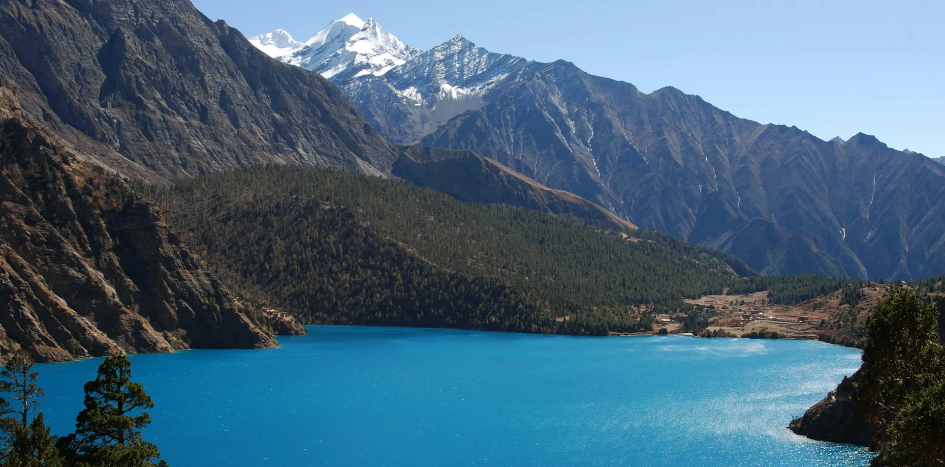
This trek mostly revolves around the Dolpa district of the Upper Dolpo region. This stunning region sits between the Tibetan Plateau and the Dhaulagiri Himalayan range, offering scenes from a unique perspective. From the many viewpoints along the way, you will get to see deep river gorges, arid landscape, lush forest, high peaks, and barren plateaus all at once. The entire Shey Phoksundo National Park will also be in the scene.
Covering over 3555 sq. km, the Shey Phoksundo National Park is a conservation effort to preserve the natural beauty of the Dolpo region along with the famous Phoksundo Lake. The national park is also home to ancient Tibetan Buddhist and Bon traditions that are still followed by the locals of the region. In villages like Saldang and Dho Tarap, you can experience centuries-old culture and lifestyle.
Back in the 8th century, Dolpo was an independent kingdom that served as a main part of the salt trade route to Tibet. Later on, it was conquered to be unified with the country of Nepal. This region opened its doors to foreigners in 1989, starting its tourism industry and trekking routes. Since then, the crystal clear, stunning Phoksundo Lake has attracted countless visitors, both nationally and internationally. Here are more aspects you need to know about this trek, stick till the end to know it all.
Price starts
US$ 4100
US$ 4200
- Safety first, always
- Best prices guaranteed
- Expert travel team
- Easy booking, no extras
- Customize your journey
Based on 10 reviews

Trip Highlights
- Visit the absolutely magnificent turquoise Shey Phoksundo Lake.
- Cross the Sehu La Pass for a panoramic scene from 5160 meters above sea level.
- Visit the Shey Gompa monastery, an 800-year-old gompa that houses many artifacts and statues.
- Traverse through the pristine nature of Tarap Valley.
- Cross the Jeng La Pass and enjoy a scene of the Dhaulagiri Himalayan Range.
- Stay a night at Saldang and experience the local culture.
- Explore the Ringmo village and visit the Phoksundo waterfall nearby.
Photo and Video Gallery


Upper Dolpo Trek Detail Itinerary
Day 01: Arrive in Kathmandu, transfer to the hotel
Day 1 of the Upper Dolpo itinerary takes you to Nepal, a land of vibrant culture and customs. After you reach the Tribhuvan International Airport in Nepal, you are supposed to work out your tourist visa. First, you will fill out a visa application form, pay your visa fees, and submit them with your passport, return tickets, proof of accommodation, and two passport-sized photos. This entire process should take around an hour to complete.
You can also apply for a tourist visa before your arrival in Nepal; this is particularly handy in peak trek seasons when the immigration booth can be a bit too crowded. The process is the same for online applications; you just have to wait 3 to 5 business days to receive your visa.
Max. Altitude: 1,400m/4,593ft. (Kathmandu)
Accommodation: Hotel
Day 02: Kathmandu sightseeing tour
The following day on the Upper Dolpo itinerary, we will go on a full-day sightseeing tour around the valley of Kathmandu. Starting off, we will visit the Bouddhanath Stupa, followed by the Swayambhunath Stupa. From there, we will head towards the Pashupatinath Temple, one of the most sacred Hindu temples in the country.
After a short break, we will head to Kathmandu Durbar Square, followed by Bhaktapur Durbar Square. Both of these sites are historic, intricately designed, and stunning. Throughout the day, we will visit a couple more sites until the evening hours.
Max. Altitude: 1,400m/4,593ft. (Kathmandu)
Accommodation: Hotel
Day 03: Fly to Nepalgunj
Starting day 3 of the Upper Dolpo itinerary with breakfast, we will head to the airport to catch our flight to Nepalgunj. This flight takes about 40 minutes, and after we exit the Nepalgunj airport, we will head to our accommodation for the night. After successfully checking in, we will go around exploring Hindu and Muslim cultures.
The entire vibe changes as we fly from Kathmandu to Nepalgunj. The weather is warmer in Nepalgunj, the plain lands are very contrasting to the valley and hills of Kathmandu. Nonetheless, you will have a great time exploring the city.
Max. Altitude: 150m/492ft. (Nepalgunj)
Accommodation: Lodge
Day 04: Fly to Juphal and trek to Dunai
On the 4th day of the Upper Dolpo itinerary, we will fly from Nepalgunj to Juphal, which takes about 20 minutes. After we arrive at the airport, we will get on a ride to a nearby camping site. This is the start of the tent nights. You will meet the trekking crew there, and they will help you set up the camp for the night. They will also cook meals for you for the entire trekking days and camping nights.
Max. Altitude: 2,000m/6,562ft. (Dunai)
Accommodation: Lodge
Day 05: Trek from Dunai to Chhepka
The first trekking day of the Upper Dolpo itinerary is here. We will start the trek crossing the Thulo Bheri River over a large suspension bridge. From there, we will head west, following the river and reach the meeting point of Suli Gaad and Thulo Bheri rivers. This point of the trek is set at 2070 meters, from where we will head north along the Suli Gaad river.
After a while of trekking, we will reach Kal Rupi village, followed by Raktang. After a short break there, we will head towards Jyalhasa village, where we will stop for lunch. The final leg of the day features crossing the Ankhe River and ascending gradually to Chhepka.
Max. Altitude: 2,670m/8,760ft. (Chhepka)
Accommodation: Tea House
Day 06: Trek to Palam
The 6th day of the Upper Dolpo itinerary features a 14 km long trail with an estimated trek duration of 6 to 7 hours. Starting from 2838 meters, we will reach 3820 meters above sea level at the end of the day, gaining a net elevation of 982 meters. However, the gross net elevation of the day is around 1200 meters, as we will be ascending and descending many undulating trails.
Leaving Chhepka, we will go over ups and downs to reach Reechi village. From there, the trail leads us to the village of Chumuwar, which takes about 2 hours of trekking. Following lunch at Chumuwar, we will hit the final ascent to Palam village.
Max. Altitude: 3,397m/11,145ft. (Palam)
Accommodation: Tea House
Day 07: Trek to Phoksundo Lake
Today’s Upper Dolpo Trek features a 4-hour trek that covers about 8 km of total distance. The net elevation loss of the day is 200 meters, reaching a final elevation of 3620 meters above sea level. The trek begins with a descent over a rocky trail. Soon, we will reach the Phoksundo River and follow it all the way to Sumduwa village. From there, we will ascend steadily towards Ringo village, the base of the Phoksundo Lake.
Max. Altitude: 3,612m/11,850ft. (Phoksundo Lake)
Accommodation: Tea House
Day 08: Rest day at Phoksundo Lake
Waking up to a stunning view of the Phoksundo Lake, the crew members will prepare a lovely breakfast. After the morning meal, we will explore the Ringo village, whose Tibetan-style houses are very charming. You can also interact with the locals and take tons of photos of the houses, chortens, and the view. We will also visit a monastery in the village and explore the shores of the Phoksundo Lake.
Max. Altitude: 3,612m/11,850ft. (Phoksundo Lake)
Accommodation: Tea House
Day 09: Trek to Salla Ghari
After a rest day at Phoksundo, today’s Upper Dolpo itinerary features a 12 km trek distance with an estimated trek duration of 5 to 6 hours. Starting from 3620 meters, we will reach 3640 meters at the end of the day, which is a negligible elevation change. However, throughout the day, we will ascend and descend about 600 meters. The initial part of the trek enters the Upper Solpo region, with views of Kanjirowa peak. Following an old trade route, we will reach our destination of the day.
Max. Altitude: 3,756m/12,323ft. (Salla Ghari)
Accommodation: Tea House
Day 10: Trek to Lar Tsa via Kang Gompa
Day 10 of the Upper Dolpo Trek features an elevation gain of 480 meters, taking us to 4120 meters above sea level, starting from 3640 meters. The trek distance of the day is 12 km with an estimated trek duration of 6 hours. Leaving Salla Ghari, we will trek a plain path and reach the Phoksundi River. Following the riverbank, we will reach Kang Gompa and traverse the grassy ridge. We will soon reach the final descent to Lar Tsa village.
Max. Altitude: 4,120m/13,517ft. (Lar Tsa )
Accommodation: Tea House
Day 11: Trek to Shey Gompa via Sehu La
On the 11th day of the Upper Dolpo itinerary, we have to cover about 15 km of distance and gain about 200 meters of net elevation, which takes about 7 to 8 hours of trekking. Starting off, we will follow the Phoksundo River and head towards the Crystal Mountain, aka Riwo Drugdra. We can also go on a circumambulation walk at the base of the peak.
After that, we will climb up to Mendok Ding La (Sehu La), a tiring ascent over rocky trails. This pass reaches a maximum elevation of 5,160 meters above sea level, making it the highest point of the Upper Dolpo Trek. After enjoying a stunning landscape scene from the top, we will hit a sharp descent and soon traverse a ridgeline to reach Tsakang Gompa. From there, we will make the final descent all the way to Shey Gompa village.
Max. Altitude: 4,200m/13,780ft. (Shey Gompa)
Accommodation: Tea House
Day 12: Acclimatization day at Shey Gompa
This is the 2nd acclimatization on the Upper Dolpo itinerary. To make the most of our time there, we will visit the Shey Gompa monastery, reaching 4390 meters above sea level. This 800-year-old monastery features handmade statues of Milarepa, Guru Rinpoche, and Sakyamuni. You will also get to see old paintings and murals from the 70s. Following the visit to the gompa, we will head back to the village and spend the rest of the day exploring it and chatting with locals.
Max. Altitude: 4,200m/13,780ft. (Shey Gompa)
Accommodation: Tea House
Day 13: Trek to Namgung via Shey La
After a restful day at Shey Gompa, today we have to cover some distance, 10 km to be precise, and gain about a hundred meters of elevation to reach Namgung village. This 6-hour trek begins with a wide trail heading east from the village. Soon enough, we will reach the ascent of Shey La Pass, climbing the pass once again, you will get to enjoy the scenes of the northern Tibetan plateau.
From the top of the pass, we will descend to Namgung village, reaching 4430 meters above sea level. The trail is steep and rocky, with arid vegetation all around. After the initial downhill part, we have to turn north and go up a gradual ascent and eventually descend again all the way to Namgung.
Max. Altitude: 4,430m/14,534ft. (Namgung)
Accommodation: Tea House
Day 14: Trek to Saldang
Day 14 is one of the shortest trekking days in the entire Upper Dolpo itinerary. The trek distance is just 6 km with an estimated duration of 3 hours. At the end of the day, we will reach 4046 meters above sea level, losing 384 meters of elevation. The trek begins with an ascent through a forested trail. Soon after, we will hit the highest point of the day, 4700 meters, offering a stunning scene of the peaks.
From there, we will start the descent to Saldang village. The slope is steep and uneven, going over rocky terrain. After a while of descending, we will reach our destination, the biggest village in the lower Dolpo region.
Max. Altitude: 3,620m/11,877ft. (Saldang)
Accommodation: Tea House
Day 15: Trek to Sibu via terraced fields
Today’s Upper Dolpo itinerary requires us to cover about 12 km of trek distance, with an estimated duration of 6 hours. The elevation loss of the day is very trivial, reaching 4000 meters above sea level from 4046 meters. However, the undulating trails en route feature about 400 meters of ups and downs.
Starting off, the trail winds up terrace farmlands, passing by stupas, mani walls, and chortens. Soon enough, we will arrive at the village of Namdo. From there, we will visit the Chaiba monastery and rest there for a bit. Continuing the trek, we have to follow the Nam Khong River all the way to Sibu village.
Max. Altitude: 3,100m/10,171ft. (Sibu )
Accommodation: Tea House
Day 16: Trek to the foot of Jeng La
Leaving Sibu, we will trek over 10 km of distance with an estimated trek duration of 4 to 5 hours. The elevation gain of the day is 480 meters, reaching 4480 meters above sea level. The initial trail offers a plain and easy path, traversing the Nam Khong river valley. At around the mid-point of the trek, we will cross streams and bridges. This trail leads us to a sharp ascent over loose rocks. As we climb up the slope, the trail steepens more, taking us to the foot of Jeng La.
Max. Altitude: 4,900m/16,076ft. (foot of Jeng La)
Accommodation: Tea House
Day 17: Trek to Tokyo Gaon via Jeng La
Day 17 of the Upper Dolpo itinerary features a descent of about 240 meters of net elevation, with an estimated trek duration of 6 to 7 hours. This trek stretches over 14 km, starting wth a steep climb to the Jeng La Pass, reaching 4850 meters above sea level. We should be able to reach the top of the pass in about 2 hours. After summiting the pass, we will descend through the Tarap valley and reach Tokyo Gaon, after about 4 hours.
Max. Altitude: 4,209m/13,809ft. (Tokyo Gaon)
Accommodation: Tea House
Day 18: Trek to Dho Tarap
This day is the shortest trekking day on the Upper Dolpo itinerary as we just have to cover about 4 km with an estimated duration of 2 hours. The elevation change is minimal, reaching 4200 meters above sea level, starting from 4200 meters. The trek starts with a gentle uphill climb traversing the Tarap valley, leading us to Kamattarka, where the Lang and Tarap Chu rivers meet. From there, we will trek forested trails until we reach Dho Tarap village.
Max. Altitude: 4,040m/13,255ft. (Dho Tarap)
Accommodation: Tea House
Day 19: Trek to Serkam
The 19th day of the Upper Dolpo Trek is a 15 km walk, losing over 570 meters of elevation, which should take about 7 hours to complete. Leaving Dho Tarap, we will follow the Tarap River downstream and pass by the ruins of past villages. After a while, we will pass by narrow gorges and cross suspension bridges to reach a wide trail. This path leads us to the campsite of Serkam, reaching 3623 meters above sea level.
Max. Altitude: 3,944m/12,940ft. (Serkam)
Accommodation: Tea House
Day 20: Trek to Tarakot
The following day, we will leave Serkam and trek for 5 hours to reach Tarakot. This trek covers about 10 km of distance with a net elevation loss of 1343 meters. Starting off, the trail crosses a suspension bridge and follows the Barbung Chu river. The trail is very undulating, climbing about 25 feet high often. Traversing this rugged terrain takes us into the Barbung Chu Valley. Soon after, we will get to our destination of the day.
Max. Altitude: 2,600m/8,530ft. (Tarakot)
Accommodation: Tea House
Day 21: Trek to Dunai
Day 21 of the Upper Dolpo Trek is about 12 km long, taking about 5 hours of time to complete. The net elevation loss is 171 meters, reaching 2109 meters above sea level. Leaving Tarakot, the trail follows the Bheri River downstream, accompanied by huge cliffs on the other side. After about 3 hours of trekking, we will reach a plain section that descends soon, leading us to Dunai village.
Max. Altitude: 2,103m/6,900ft. (Dunai)
Accommodation: Tea House
Day 22: Trek to Juphal
Today is yet another short trekking day on the Upper Dolpo Trek. Leaving Dunai, we have to cover just 6 km to get to Juphal, which takes about 3 hours of trekking. The elevation gain of the day is 366 meters, starting with a flat trail alongside the Bheri River. Passing by terrace farmlands, the landscape transitions gradually as we exit the highland region. After our arrival at Juphal, we will set up a camp for the night.
Max. Altitude: 2,400m/7,874ft. (Juphal)
Accommodation: Tea House
Day 23: Fly to Kathmandu via Nepalgunj
Following the last trekking day on the Upper Dolpo Trek, we will fly out to Nepalgunj early in the morning after breakfast. From Nepalgunj, we will take a same-day flight to Kathmandu. The changes in scenes from Juphal to Nepalgunj and Nepalgunj to Kathmandu are very dramatic.
Max. Altitude: 1,400m/4,593ft. (Kathmandu )
Accommodation: Lodge
Day 24: Depart from Nepal
This is the last day on the Upper Dolpo Trek. After a morning breakfast in Kathmandu, we will have you escorted to the airport at your preferred time of the day. We will also have a small farewell ceremony with the hope that you enjoyed the time with us, and also to see you again soon for another Himalayan adventure.
If our standard itinerary doesn't fully meet your needs, we are happy to tailor it to your specific preferences and requirements.
Includes and Excludes
What’s Included?
- Airport transfers in Kathmandu, including pickup on arrival and drop-off on departure
- Domestic flights from Kathmandu to Nepalgunj, then Nepalgunj to Juphal (trek start point), both ways
- Hotel accommodation in Kathmandu before and after the trek
- Comfortable teahouse or lodge accommodation during the trek (twin-sharing)
- Breakfast in Kathmandu hotel, and three meals (breakfast, lunch, dinner) each day during the trek
- Professional, English-speaking trekking guide and required porters
- Trekking guide salary, insurance, meals, accommodation, equipment, transportation, etc.
- Seasonal fresh fruit during the trek
- All necessary trekking permits and national park entry fees
- Basic medical kit and safety equipment during the trek
- Sleeping bag, down Jacket, walking poles, duffel bags (you have to return after the trek)
- Certificate of achievement at the end of the journey
- Government taxes and agency service charges
What is not Included?
- International flights to and from Nepal
- Nepal entry visa fees upon arrival
- Lunch and dinner in Kathmandu
- Personal expenses such as drinks, snacks, hot showers, Wi-Fi, and device charging
- Travel insurance that covers medical emergencies and helicopter evacuation
- Tips for guides, porters, and drivers
- Extra hotel nights caused by flight delays, early arrival, or late departure
- Personal Travel insurance and emergency rescue evacuation
- Extra cost caused by natural or political disturbances beyond our control
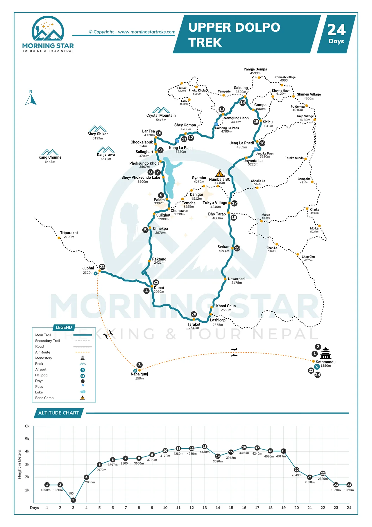
Route Map & Altitude Chart
Trip Information of Upper Dolpo Trek
Best season and weather
The best season for the Upper Dolpo Trek is definitely autumn, although the season is known for falling leaves, there are many great aspects it offers. First of all, this season offers very minimal precipitation with clear blue skies. Second, the daytime temperature is very mild, making it perfect to do outdoor activities like trekking. Lastly, the trails are dry during this season, and the visibility is the clearest.
Difficulty
The Upper Dolpo Trek is considered to be a challenging trek, with a difficulty level of 9 out of 10. This trek features many ascents and descents over undulating trails and high mountain passes. Out of the 24 days, we will spend 15 days over 3500 meters of elevation and 9 nights at over 4000 meters above sea level. The altitude makes it harder for us to trek while the slope of the trails rises and falls sharply.
Altitude Sickness
The itinerary we have discussed above requires us to spend over a week above 4000 meters, which can induce altitude sickness if we are not careful enough. Our experienced trek guide will help you understand the preventive measures of altitude sickness so that you are as safe as possible.
We will also climb high and sleep low, which has proven to be the best preventive measure of altitude sickness. Additionally, there are 2 acclimatization days on the itinerary that will help your body adapt to the changes in environment and atmosphere.
Preparation and Fitness
This trek is genuinely one of the most difficult trekking destinations in Nepal. However, with proper preparation and great physical fitness, you can complete the trek with some effort. The training period must be 20 to 24 weeks long as we expect you to be more than ready for the hardships the trails present. Training your leg muscles and improving your endurance will help you complete this trek with no major setbacks.
Food and Accommodation
Along with the national dish of Dal Bhat, you can taste Kaguno, Chino, Dhido, different types of veg and non-veg curry, Tsampa, Fini roti, Su-cha, etc. As long as you like the taste, we encourage trekkers to eat the local produce instead of the packaged Western options. Accommodation expenses throughout the trek will be covered by the trek package, and we will be spending our nights in tents for the entire trekking days.
Transportation
The Upper Dolpo Trek itinerary requires us to fly to Nepalgunj, followed by a flight to Juphal, at the start of the trek. At the end of the trek, we will fly back to Nepalgunj from Juphal and take a flight to Kathmandu. All of these transportation costs will be covered by the package.
Communication
Getting a network on your phone is not a possibility during the trekking days, as we will be traveling to remote villages. You are also not likely to find WiFi connections at tea houses. However, the trek guide will be holding a satellite phone to contact emergency services in times of need.
Permit
For this trek, trekkers are required to have a Shey Phoksundo National Park Entry Permit, a
Upper Dolpo Restricted Area Permit and a Lower Dolpo Restricted Area Permit. All the permit fees are a part of the trek package.
Visa
Your visa fees upon arrival at the Tribhuvan International Airport are not covered by the package. Those are considered to be personal expenses that are not included in the package.
Travel Insurance
Much like visa fees, travel insurance is very important; without it, you can not join the trek. But it is considered to be a personal expense, so it will not be covered by the package.
Extra Expenses
Your extra expenses are visa fees, travel insurance fees, tips for the crew members, extra meals, lunch and dinner in cities, additional night stays, etc.
Private vs. group trek
A private trek to the Upper Dolpo region means experiencing the trek with your close ones and your loved ones. You can bring along anyone you want to as long as they are fit for the trek and have prepared well. On the other side, a group trek will have you amidst random people and share the tents and rooms with one of the fellow trekkers in the group.
Most Asked Questions
![]() General
General
How does the Upper Dolpo Trek’s remoteness compare to other restricted area treks like Nar Phu or Mustang?
While the Mustang region is fairly accessible, the Nar Phu valley and Upper Dolpo region are similar in terms of remoteness.
Are there specific festivals or events in Dolpo that might align with the trekking season?
During the month of September (autumn season), you may experience the Shey Festival, which is celebrated once every 12 years.
What are the challenges of crossing high passes like Sehu La?
In general, you can expect icy patches all over with loose rocky trails that require careful footing.
Can I visit other nearby cultural sites, like Sandul Gompa, during the trek?
Yes, en route, we will visit many gompa and monasteries that showcase traditional Tibetan Buddhism architecture.
What are the main differences between the Upper and Lower Dolpo trekking routes?
The main differences can be filtered down to high ascents and increased chances of altitude sickness.
![]() Preparation & Fitness
Preparation & Fitness
What kind of diet should I take for the Upper Dolpo Trek preparation?
There is no recommended or specific dietary requirement for preparing for this trek. You can just have what you usually do, but make sure to maintain a healthy fitness level.
How much weight should I expect to carry in my daypack on days like the trek to Saldang?
Throughout the trek, you will carry about 3 to 4 kg of stuff on your day pack, including a water bottle, phone, camera (if you decide to take one), energy bars, snacks, etc.
Are trekking poles necessary for the rocky descents, such as from Jeng La to Tokyo Gaon?
Yes, trekking poles save your knees from the constant pressure you feel when you descend any sharp lopes, such as the descent from Jeng La Pass.
What prior trekking experience is recommended for handling the Upper Dolpo Trek’s high-altitude terrain?
Trekkers must have prior Himalaya trekking experience to be able to join this trek, since this trek is graded as a challenging journey.
How can I build stamina for long trekking days, like the 7–8 hour trek to Shey Gompa?
You can go on jogs, hit the treadmill, or simply walk for hours every day to build up enough stamina.
![]() Insurance and Visa
Insurance and Visa
What are the processing times for the Upper Dolpo Restricted Area Permit?
You can get the permit on the same day of application.
Is a standard Nepal tourist visa enough for the Upper Dolpo Trek?
A standard tourist visa is enough to enter Nepal, but you must have permits to do the trek.
Does travel insurance need specific coverage for remote trekking in Upper Dolpo?
Yes, your travel insurance package must cover helicopter evacuations and medical expenses at high, remote locations.
How can I verify that my insurance policy covers cancellations due to unpredictable weather?
You can simply ask the insurance broker to point out the specific information that you need to know about.
Are there any age or health restrictions for obtaining the Upper Dolpo trekking permits?
No, there are no age or health restrictions for obtaining the Upper Dolpo trekking permits. However, kids under 12 must not join the trek.
Where in Kathmandu can I secure the Shey Phoksundo National Park Entry Permit?
You can obtain it at the Tourism Board Office.
![]() Guides & Support Staff
Guides & Support Staff
Do guides for the Upper Dolpo Trek need specialized training for navigating restricted areas?
Yes, they need to have at least 3 or 4 years of experience trekking in the region.
How many porters are typically assigned to carry supplies?
Porters are assigned randomly; each porter can carry up to 24 kg, shared by two trekkers in the group.
What is the protocol for tipping guides and porters at the end of the Upper Dolpo Trek?
At the end of the trek, you can tip the crew members as much as you would like to; there is no standard amount.
How do guides ensure safety during challenging sections?
The guide will climb up first and direct the trekkers on how to traverse the slopes.
Are porters responsible for setting up tents and cooking at campsites like Serkam?
Yes, the porters and guides will set up the tents and cook meals for the trekkers.
![]() Accommodation and Facilities
Accommodation and Facilities
What are the sleeping arrangements like in tented camps?
You will share the tent with one of the trekkers in the group.
![]() Food and Drinks
Food and Drinks
What traditional Dolpo foods, like marsi rice or tsampa, can I expect at campsites or villages?
While campsites heavily rely on packaged food, you can expect dishes like Kaguno, Chino, Dhido, etc., at villages.
Are there provisions for dietary restrictions, such as gluten-free or allergy-friendly meals?
While there are no set rules in place, you can just avoid food that you are allergic to.
How is drinking water sourced and treated in remote areas?
Drinking water is sourced from natural springs, but they are usually untreated.
Can I request additional snacks or energy foods for long trekking days?
Yes, you can request additional meals, but it will come at a price, not included in the package.
![]() Weather & Seasons
Weather & Seasons
What are the typical daytime and nighttime temperatures like in Upper Dolpo during peak trekking months?
Generally, the daytime temperatures remain very mild, while the nighttime temperatures can be a bit cold.
How do snow or ice conditions on passes like Jeng La affect the trek’s schedule?
During the peak trekking seasons, you will not experience snow or ice conditions on passes.
Are there specific times of year when Phoksundo Lake’s views are most vibrant?
During the months of September, October, and November, you can expect the lake to have the best view.
What are the risks of high winds in open areas like the glacial valley near Lar Tsa?
There are no risks related to high winds; you will experience some gusts, but they are harmless.
How does the trekking agency adjust the itinerary if weather delays occur at high-altitude camps?
If weather delays occur at high-altitude camps, we have no other choice but to wait for the weather to clear. The expenses incurred by such conditions are not a part of the Upper Dolpo Trek package.
When is the best season to avoid cloud cover for clear views of peaks like Kanjirowa Himal?
You must do this trek in autumn to have the best chances of no clouds blocking the stunning views of the Kanjirowa Himal.
![]() Health & Safety
Health & Safety
What are the symptoms of altitude sickness to watch for at high camps like Namgung or Lar Tsa?
You must watch out for light-headedness, nausea, shortness of breath, and a slight headache. These are the common symptoms of altitude sickness.
Are basic medical supplies available at campsites, or should I carry my own first aid kit?
Yes, basic medical supplies are available at campsites, but we will also carry our own first aid kits as we might need them in the middle of nowhere.
How are emergency evacuations coordinated in remote areas like the Tarap Valley?
The trek guide will use a satellite phone to contact the emergency rescue services, who will send in a helicopter to rescue the injured.
Are there risks of hypothermia at high-altitude camps like the foot of Jengla?
No, there are no risks of hypothermia at high-altitude camps. The coldness in such a region is not enough to induce hypothermia.
What safety measures are in place for crossing rivers or unstable bridges near Tarakot?
Although the bridges appear unstable at first glance, they are actually stable enough to support many trekkers at once.
![]() Booking & Payment
Booking & Payment
How does the booking process ensure timely permit acquisition for Upper Dolpo Trek?
Before your arrival in Nepal, our reps will ask you for some documents and details to obtain the permits on your behalf.
What is the deadline for booking the Upper Dolpo Trek?
There is no deadline since the flow of trekkers can not be expected.
What are the refund terms if I cancel?
As per the time of cancellation, we will hold a certain portion of the initial deposit and return the rest.
Are there additional fees for itinerary changes, like extra days at Shey Gompa?
Yes, itinerary changes require additional fees, but simple and minor changes might not affect the overall price sometimes.
Can I book a private Upper Dolpo Trek for a smaller group?
Yes, you can; however, the group must have at least 4 people.
![]() Transportation & Flight
Transportation & Flight
How often do flights from Nepalgunj to Juphal operate?
Flights from Nepalgunj to Juphal operate every Tuesday and Saturday early in the morning. So, we need to plan the itinerary with that in mind, so we do not have to spend extra days in any place.
What is the baggage allowance for personal gear on the small aircraft to Juphal?
Around 5 kg of hand-carried baggage is allowed on the small aircraft to Juphal.
Are there alternative routes to reach Dunai if flights to Juphal are grounded for multiple days?
Yes, there are roadways to reach Dunai from Nepalgunj, but it will take multiple hours, and the road conditions are not that great. You will experience a bumpy and remote path.
How is transportation arranged from the hotel in Kathmandu to the domestic airport for the Nepalgunj flight?
One of our drivers or reps will drop you off at the airport for your flight to Nepalgunj. We will also drop you off at the airport at the end of the trek.
Price starts
US$ 4100
US$ 4200
- Safety first, always
- Best prices guaranteed
- Expert travel team
- Easy booking, no extras
- Customize your journey
Based on 10 reviews
Have Questions?
+977 9767224414